
Make a donation
Gear up for your next adventure:
As an Amazon Associate, this site earns from qualifying purchases at no extra cost to you.
Mangonia Park topographic map
Click on the map to display elevation.
Make a donation
Gear up for your next adventure:
As an Amazon Associate, this site earns from qualifying purchases at no extra cost to you.
About this map
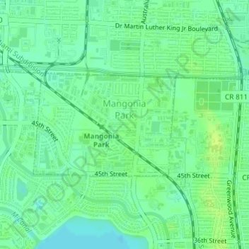
Name: Mangonia Park topographic map, elevation, terrain.
Location: Mangonia Park, Palm Beach County, Florida, United States (26.75311 -80.08475 26.76430 -80.06746)
Average elevation: 26 ft
Minimum elevation: 3 ft
Maximum elevation: 49 ft
Palm Beach County trails, hiking, mountain biking, running and outdoor activities
Make a donation
Gear up for your next adventure:
As an Amazon Associate, this site earns from qualifying purchases at no extra cost to you.
Other topographic maps
Click on a map to view its topography, its elevation and its terrain.
Make a donation
Gear up for your next adventure:
As an Amazon Associate, this site earns from qualifying purchases at no extra cost to you.
Make a donation
Gear up for your next adventure:
As an Amazon Associate, this site earns from qualifying purchases at no extra cost to you.
Make a donation
Gear up for your next adventure:
As an Amazon Associate, this site earns from qualifying purchases at no extra cost to you.
Loxahatchee Groves
United States > Florida > Palm Beach County > Loxahatchee Groves
Average elevation: 30 ft
Caribbean Key
United States > Florida > Palm Beach County > Boca Raton > Caribbean Key
Average elevation: 16 ft
Make a donation
Gear up for your next adventure:
As an Amazon Associate, this site earns from qualifying purchases at no extra cost to you.
Morikami Museum and Japanese Gardens
United States > Florida > Palm Beach County > Delray Beach
Average elevation: 30 ft