
Aberdeen topographic map
Click on the map to display elevation.
About this map
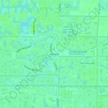
Name: Aberdeen topographic map, elevation, terrain.
Location: Aberdeen, Palm Beach County, Florida, 33437, United States (26.53063 -80.16866 26.57063 -80.12866)
Average elevation: 30 ft
Minimum elevation: 13 ft
Maximum elevation: 39 ft
Palm Beach County trails, hiking, mountain biking, running and outdoor activities
Other topographic maps
Click on a map to view its topography, its elevation and its terrain.
Lake Clarke Shores
United States > Florida > Palm Beach County
In the early 1930s, Zeb Vance Hooker and his family became the first settlers in modern-day Lake Clarke Shores by squatting in a wooden shack on land by the southeast side of Lake Clarke. In 1946, Patsy Renolds built a house where Antigua Road stands today and is the oldest home in Lake Clarke Shores. By the…
Average elevation: 26 ft
Morikami Museum and Japanese Gardens
United States > Florida > Palm Beach County > Delray Beach
Average elevation: 30 ft