Geolocate

Pudukkottai topographic map

Click on the map to display elevation.

About this map

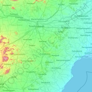
Name: Pudukkottai topographic map, elevation, terrain.

Location: Pudukkottai, Pudukkottai District, Tamil Nadu, India (9.80000 78.13333 11.20000 79.53333)

Average elevation: 312 ft

Minimum elevation: -7 ft

Maximum elevation: 3,238 ft

Other topographic maps

Click on a map to view its topography, its elevation and its terrain.

Coimbatore District

India > Tamil Nadu

Apart from the species common to the plains, wild elephants, wild boars leopards, tigers, bison, species of deer, Nilgiri tahr, sloth bear and black-headed oriole can be found. The Anamalai Wildlife Sanctuary 88 km (55 mi) in the Western Ghats at an altitude of 1,400 meters covers an area of 958 km2. More than…

Average elevation: 1,808 ft

KOLLI HILLS

India > Tamil Nadu

Average elevation: 1,847 ft

Kodaikanal

India > Tamil Nadu

Average elevation: 2,851 ft

Gudalur

India > Tamil Nadu

Average elevation: 3,717 ft

Nilgiris

India > Tamil Nadu

The district has an area of 2,552.50 km2. The district is basically hilly, lying at an elevation of 1,000 to 2,600 metres above MSL, and divided between the Nilgiri plateau and the lower, smaller Wayanad plateau. The district lies at the juncture of the Western Ghats and the Eastern Ghats. Its latitudinal and…

Average elevation: 3,199 ft

Poonamallee

India > Tamil Nadu

Average elevation: 95 ft

Bodinayakanur

India > Tamil Nadu

Average elevation: 2,933 ft

Tiruchengode

India > Tamil Nadu

Average elevation: 735 ft

Kallu Kuttai Lake

India > Tamil Nadu

Average elevation: 20 ft

Tiruchirappalli District

India > Tamil Nadu

Average elevation: 502 ft

Madipakkam Lake

India > Tamil Nadu > Chennai

Average elevation: 33 ft

Vedaranyam

India > Tamil Nadu

Average elevation: 3 ft

Salem

India > Tamil Nadu

Salem is located at 11°40′N 78°08′E / 11.67°N 78.14°E / 11.67; 78.14, at an average elevation of 278 m (912 ft.). The city is surrounded by hills: Nagaramalai on the north, Jarugumalai on the south, Kanjamalai on the west, Godumalai on the east and the Shevaroy Hills on the northeast.…

Average elevation: 1,312 ft

Ramanathapuram

India > Tamil Nadu

Average elevation: 26 ft

Pallavaram

India > Tamil Nadu

Average elevation: 69 ft

Sivagangai District

India > Tamil Nadu

Average elevation: 243 ft

MPT Ground

India > Tamil Nadu > Chennai

Average elevation: 20 ft

Nanmangalam Lake

India > Tamil Nadu > Pallavaram

Average elevation: 49 ft

Erode District

India > Tamil Nadu

Western Ghats runs through the district and it is straddled by Eastern Ghats which is separated by Moyar River. The region comprises the high altitude regions of the north sloping gently towards a long undulating plain in the south. Bhavani River cuts the district roughly in the middle, flowing from west to…

Average elevation: 1,680 ft

Thalavadi

India > Tamil Nadu

Average elevation: 2,808 ft

Thiruvallur

India > Tamil Nadu

The northern taluks of the district like Ponneri, Uttukkottai, Gummidipundi etc. do not have much to offer from the scenic point of view. In the Tiruttani taluk, a number of hillocks are found scattered. The soil of the district is mostly sandy, mixed with soda or other alkali or stony. Rocks found in and near…

Average elevation: 164 ft

Mayiladuthurai

India > Tamil Nadu

Average elevation: 33 ft

Yercaud

India > Tamil Nadu

Average elevation: 2,365 ft

Kotagiri

India > Tamil Nadu

Average elevation: 3,422 ft

Vanur

India > Tamil Nadu

Average elevation: 82 ft

Pattukkottai

India > Tamil Nadu

Average elevation: 52 ft

Nambiyur

India > Tamil Nadu

Average elevation: 942 ft

Karur

India > Tamil Nadu > Karur

Karur is located at 10°57′N 78°05′E / 10.95°N 78.08°E / 10.95; 78.08 and has an average elevation of 101 metres or 331 feet. The town is located in Karur district of the South Indian state, Tamil Nadu, at a distance of 370 km (230 mi) from Chennai.

Average elevation: 423 ft

Rasipuram

India > Tamil Nadu

Average elevation: 1,286 ft

Tiruchendur

India > Tamil Nadu

Average elevation: 30 ft

Vedasandur

India > Tamil Nadu

Average elevation: 863 ft

Muthupet

India > Tamil Nadu > Thiruthuraipoondi

Average elevation: 13 ft

Then Pennai

India > Tamil Nadu > Hosur > Thorapalli Agraharam

Average elevation: 2,717 ft

Mannargudi

India > Tamil Nadu

Average elevation: 49 ft

Viluppuram District

India > Tamil Nadu

Average elevation: 190 ft

Virudhachalam

India > Tamil Nadu

Average elevation: 167 ft

Kumarapalayam

India > Tamil Nadu

Average elevation: 656 ft

Kadavur

India > Tamil Nadu

Average elevation: 699 ft

Cuddalore

India > Tamil Nadu > Cuddalore

Cuddalore is located at 11°45′N 79°45′E / 11.75°N 79.75°E / 11.75; 79.75. It has an average elevation of 6 m (20 ft). The land is completely flat with large black and alluvial soil inland and coarse sand near the seashore. The sandstone deposits in the town are popular. The Pennayar River runs north of…

Average elevation: 26 ft

Tiruvannamalai

India > Tamil Nadu > Tiruvannamalai

Tiruvannamalai is situated 196 km (122 mi) from the state capital Chennai and 210 km (130 mi) from Bangalore. The height of the Annamalai hill is approximately 2,669 ft (814 m). Tiruvannamalai is located at 12°00′N 79°03′E / 12°N 79.05°E / 12; 79.05. It has an average elevation of 200 metres…

Average elevation: 663 ft

Mohanur

India > Tamil Nadu

Average elevation: 587 ft

Madurai

India > Tamil Nadu > Madurai

Madurai is located at 9°56′N 78°07′E / 9.93°N 78.12°E / 9.93; 78.12. It has an average elevation of 101 metres. The city of Madurai lies on the flat and fertile plain of the river Vaigai, which runs in the northwest-southeast direction through the city, dividing it into two almost equal…

Average elevation: 453 ft

Edappadi

India > Tamil Nadu

Average elevation: 896 ft

Rajapalayam

India > Tamil Nadu > Rajapalayam

Average elevation: 551 ft

Anthiyur

India > Tamil Nadu

Average elevation: 1,667 ft

Ponneri

India > Tamil Nadu

Average elevation: 20 ft

Ward 116

India > Tamil Nadu

Average elevation: 20 ft

Thirumoorthi Dam

India > Tamil Nadu > Udumalaipettai

Average elevation: 1,417 ft

Vaniyambadi

India > Tamil Nadu

Average elevation: 1,834 ft

Erode

India > Tamil Nadu

Average elevation: 669 ft

Pollachi

India > Tamil Nadu

Average elevation: 1,099 ft

Valangaiman

India > Tamil Nadu

Average elevation: 89 ft

Madurai District

India > Tamil Nadu

Average elevation: 873 ft

Kookal Lake

India > Tamil Nadu > Kodaikanal > Kookal

Average elevation: 6,289 ft

Zone 9 Teynampet

India > Tamil Nadu > Chennai

Average elevation: 33 ft

Chetpet

India > Tamil Nadu

Average elevation: 482 ft

Vikravandi

India > Tamil Nadu

Average elevation: 246 ft

Pappireddipatti

India > Tamil Nadu

Average elevation: 1,893 ft

Tharangambadi

India > Tamil Nadu

Average elevation: 16 ft

Vellore Fort

India > Tamil Nadu > Vellore > Vellore

It is mentioned that "there is no such fort on the face of earth like the one in Vellore. It had a deep wet ditch (moat) where once 10,000 crocodiles swarmed, waiting to grab every intruder into this impregnable fort. It has huge double walls with bastions projecting irregularly, where two carts can be driven…

Average elevation: 702 ft

Kalakkad Mundanthurai Tiger Reserve

India > Tamil Nadu > Ambasamudram

The reserve spans a range of 40 to 1,800 m in elevation. Agasthiyamalai (1681 m.) is in the core zone of the reserve.

Average elevation: 1,296 ft

Kallakurichi

India > Tamil Nadu

Average elevation: 591 ft

Arcot

India > Tamil Nadu > Arcot

Arcot is located at 12°54′N 79°20′E / 12.9°N 79.33°E / 12.9; 79.33. It has an average elevation of 164 metres (538 ft).

Average elevation: 554 ft

Kanjamalai

India > Tamil Nadu > Salem West

Average elevation: 1,181 ft

Aliyar Dam

India > Tamil Nadu > Pollachi > Aliyaar

Average elevation: 994 ft

Natham

India > Tamil Nadu > Natham

Average elevation: 1,007 ft

Valparai

India > Tamil Nadu

Average elevation: 3,071 ft

Uthamapalayam

India > Tamil Nadu

Average elevation: 2,306 ft

Zone 10 Kodambakkam

India > Tamil Nadu > Chennai

Average elevation: 43 ft

Zone 2 Manali

India > Tamil Nadu > Mathavaram

Average elevation: 20 ft

Sendamangalam

India > Tamil Nadu

Average elevation: 1,263 ft

Rameswaram

India > Tamil Nadu

Average elevation: 0 ft

Athoor

India > Tamil Nadu

Average elevation: 1,539 ft

Sivagiri

India > Tamil Nadu

Average elevation: 1,745 ft

Vembakkam

India > Tamil Nadu

Average elevation: 348 ft

Vandavasi

India > Tamil Nadu

Average elevation: 276 ft

Cheranmahadevi

India > Tamil Nadu

Average elevation: 361 ft

Veerabadhra Nagar

India > Tamil Nadu > Sholinganallur

Average elevation: 26 ft

Chennai metropolitan area

India > Tamil Nadu > Ambattur

Average elevation: 59 ft

Attur

India > Tamil Nadu

Average elevation: 1,572 ft

Gudiyatham

India > Tamil Nadu

Average elevation: 1,594 ft

Uthangarai

India > Tamil Nadu

Average elevation: 1,263 ft

Nannilam

India > Tamil Nadu

Average elevation: 39 ft

Omalur

India > Tamil Nadu

Average elevation: 1,401 ft

Krishnarayapuram

India > Tamil Nadu

Average elevation: 417 ft

Arul Nagar Park

India > Tamil Nadu > Tambaram > Tambaram

Average elevation: 92 ft

Peraiyur

India > Tamil Nadu

Average elevation: 876 ft

Tirunelveli District

India > Tamil Nadu

Located between 1,000 metres (3,300 ft) and 1,500 metres (4,900 ft) of elevation, the Manjolai area is set deep within the Western Ghats within the Kalakad Mundanthurai Tiger Reserve in the Tirunelveli District. Located on top of the Manimuthar Dam and the Manimuthar Water Falls, the Manjolai area comprises…

Average elevation: 643 ft

Sriperumbudur

India > Tamil Nadu

Average elevation: 157 ft

Peravurani

India > Tamil Nadu

Average elevation: 62 ft

Tirupathur

India > Tamil Nadu

Average elevation: 1,581 ft

Chengam

India > Tamil Nadu

Average elevation: 1,234 ft

Gandharvakottai

India > Tamil Nadu > Gandarvakottai taluk

Average elevation: 253 ft

vadavalli

India > Tamil Nadu > Mettupalayam

Average elevation: 1,145 ft

Mogappair west park

India > Tamil Nadu > Ambattur

Average elevation: 49 ft

Gear up for your next adventure:

🛠️Outdoor Gear Repair Kit - Essential tools to fix gear on the trail
🌡️Handheld Weather Meters - Measure wind, temp, and pressure for safe mountain travel
🥤Water Filter Bottle - All‑in‑one filter bottle for safe hydration
🔭Compact Binoculars - HD vision for scouting terrain and identifying distant landmarks
🛡️Insect Repellent - Protection against bugs during outdoor activities

As an Amazon Associate, this site earns from qualifying purchases at no extra cost to you.