
Make a donation
Gear up for your next adventure:
As an Amazon Associate, this site earns from qualifying purchases at no extra cost to you.
Breitenburg topographic map
Click on the map to display elevation.
Make a donation
Gear up for your next adventure:
As an Amazon Associate, this site earns from qualifying purchases at no extra cost to you.
Breitenburg
Im Jahre 1526 erwarb Johann Rantzau die Geesthöhe, indem er die Ländereien des Klosters Bordesholm im Kirchspiel Breitenberg an der Stör, die durch eine Überschwemmung verödet waren, ankaufte. Hier befindet sich heute die Gemeinde. Johann Rantzau ließ hier im Jahr 1531 sein festes Schloss Breitenburg bauen, welches sich seit dem fast ununterbrochen im Besitz der Grafen Rantzau befand. Die Herrschaft Breitenburg vererbte sich auf seinen Sohn, den Statthalter Heinrich, während das Gut Bothkamp dem jüngeren Sohn Paul zufiel.
Make a donation
Gear up for your next adventure:
As an Amazon Associate, this site earns from qualifying purchases at no extra cost to you.
About this map
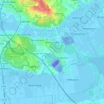
Name: Breitenburg topographic map, elevation, terrain.
Location: Breitenburg, Kreis Steinburg, Schleswig-Holstein, Deutschland (53.87137 9.48892 53.91205 9.64944)
Average elevation: 16 ft
Minimum elevation: -335 ft
Maximum elevation: 236 ft
Make a donation
Gear up for your next adventure:
As an Amazon Associate, this site earns from qualifying purchases at no extra cost to you.
Other topographic maps
Click on a map to view its topography, its elevation and its terrain.
Rhinplate und Elbufer südlich Glückstadt
Deutschland > Schleswig-Holstein > Kreis Steinburg > Kollmar
Average elevation: 0 ft
Make a donation
Gear up for your next adventure:
As an Amazon Associate, this site earns from qualifying purchases at no extra cost to you.
Make a donation
Gear up for your next adventure:
As an Amazon Associate, this site earns from qualifying purchases at no extra cost to you.
Springhoe
Deutschland > Schleswig-Holstein > Kreis Steinburg > Hohenlockstedt
Average elevation: 66 ft
Kaaksburg
Deutschland > Schleswig-Holstein > Kreis Steinburg > Kaaks
Über ihre Entstehung und Funktion ist nicht viel bekannt. Der ovale Ringwall mit einem Durchmesser von 80 bzw. 100 m und einer Höhe von ca. 5 m wurde aus dunkler Erde aufgeworfen, während der Boden in der Umgebung sandig ist, weshalb angenommen wurde, dass das Material aus der im Südosten vorbeifließenden…
Average elevation: 36 ft
Make a donation
Gear up for your next adventure:
As an Amazon Associate, this site earns from qualifying purchases at no extra cost to you.
Springhoe
Deutschland > Schleswig-Holstein > Kreis Steinburg > Hohenlockstedt
Average elevation: 66 ft