
Make a donation
Gear up for your next adventure:
As an Amazon Associate, this site earns from qualifying purchases at no extra cost to you.
Latakia Governorate topographic map
Click on the map to display elevation.
Make a donation
Gear up for your next adventure:
As an Amazon Associate, this site earns from qualifying purchases at no extra cost to you.
Latakia Governorate
The Latakia Governorate comprises about half of Syria's Mediterranean coastline. The western part of the governorate consists mainly of coastal plains, with the inland eastern parts being mountainous, with the Syrian Coastal Mountain Range (Nusayriyah Mountains) running north to south. Its highest peak, Nabi Yunis, is 1,562 meters (5,125 ft) tall with the average elevation only about 1,200 meters. The western areas of the governorate catch moisture-laden winds from the Mediterranean Sea and are thus more fertile and more heavily populated than the eastern slopes.
Make a donation
Gear up for your next adventure:
As an Amazon Associate, this site earns from qualifying purchases at no extra cost to you.
About this map
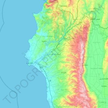
Name: Latakia Governorate topographic map, elevation, terrain.
Location: Latakia Governorate, Syria (35.21667 35.71657 35.94057 36.25519)
Average elevation: 846 ft
Minimum elevation: 0 ft
Maximum elevation: 5,049 ft
Make a donation
Gear up for your next adventure:
As an Amazon Associate, this site earns from qualifying purchases at no extra cost to you.
Other topographic maps
Click on a map to view its topography, its elevation and its terrain.
Make a donation
Gear up for your next adventure:
As an Amazon Associate, this site earns from qualifying purchases at no extra cost to you.
Make a donation
Gear up for your next adventure:
As an Amazon Associate, this site earns from qualifying purchases at no extra cost to you.
Make a donation
Gear up for your next adventure:
As an Amazon Associate, this site earns from qualifying purchases at no extra cost to you.
Make a donation
Gear up for your next adventure:
As an Amazon Associate, this site earns from qualifying purchases at no extra cost to you.
Masyaf
Masyaf is situated along the foothills of the eastern slopes of the Jabal Ansariyah coastal mountain range. The average elevation of Masyaf is 485 meters. It is just west of the al-Ghab Plain. The area is marked by gardens, orchards and fields of wheat and barley which are cultivated by local residents. To the…
Average elevation: 1,929 ft
Make a donation
Gear up for your next adventure:
As an Amazon Associate, this site earns from qualifying purchases at no extra cost to you.
Make a donation
Gear up for your next adventure:
As an Amazon Associate, this site earns from qualifying purchases at no extra cost to you.
Beludan
Syria > Rif Dimashq Governorate
Bloudan (Arabic: بلودان, romanized: Blūdān) is a Syrian village located 51 kilometers north-west of Damascus, in the Rif Dimashq Governorate; it has an altitude of about 1500 meters. In the 2004 census by the Central Bureau of Statistics it had a population of 3,101. The majority of the inhabitants are…
Average elevation: 5,131 ft
Make a donation
Gear up for your next adventure:
As an Amazon Associate, this site earns from qualifying purchases at no extra cost to you.
Make a donation
Gear up for your next adventure:
As an Amazon Associate, this site earns from qualifying purchases at no extra cost to you.
Make a donation
Gear up for your next adventure:
As an Amazon Associate, this site earns from qualifying purchases at no extra cost to you.
Make a donation
Gear up for your next adventure:
As an Amazon Associate, this site earns from qualifying purchases at no extra cost to you.
Make a donation
Gear up for your next adventure:
As an Amazon Associate, this site earns from qualifying purchases at no extra cost to you.
Make a donation
Gear up for your next adventure:
As an Amazon Associate, this site earns from qualifying purchases at no extra cost to you.
Make a donation
Gear up for your next adventure:
As an Amazon Associate, this site earns from qualifying purchases at no extra cost to you.
Ziyarat ash Shaykh Faris
Syria > Homs Governorate > Ziyarat ash Shaykh Faris
Average elevation: 1,227 ft
Make a donation
Gear up for your next adventure:
As an Amazon Associate, this site earns from qualifying purchases at no extra cost to you.
Make a donation
Gear up for your next adventure:
As an Amazon Associate, this site earns from qualifying purchases at no extra cost to you.