Geolocate

Texel topographic map

Click on the map to display elevation.

About this map

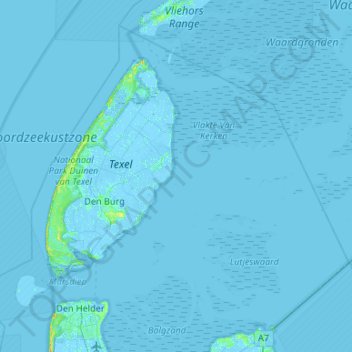
Name: Texel topographic map, elevation, terrain.

Location: Texel, North Holland, Netherlands (52.94107 4.61300 53.21427 5.14428)

Average elevation: 0 ft

Minimum elevation: -20 ft

Maximum elevation: 56 ft

Other topographic maps

Click on a map to view its topography, its elevation and its terrain.

Haarlem

Netherlands > North Holland > Haarlem

Average elevation: 0 ft

Zuid-Haffel

Netherlands > North Holland > Den Burg

Average elevation: 0 ft

Anna's Berg

Netherlands > North Holland > Hilversum

Average elevation: 20 ft

Spaarndam

Netherlands > North Holland

Average elevation: 0 ft

Schellingwoude

Netherlands > North Holland > Amsterdam

Average elevation: 3 ft

Valkeveen

Netherlands > North Holland > Naarden

Average elevation: 7 ft

Tafelberg

Netherlands > North Holland > Huizen

Average elevation: 49 ft

Zaan

Netherlands > North Holland > Zaandam

Average elevation: 7 ft

Strandslag 37

Netherlands > North Holland > Castricum

Average elevation: 13 ft

Klet

Netherlands > North Holland > Broek op Langedijk

Average elevation: 0 ft

Catrijp

Netherlands > North Holland > Schoorl

Average elevation: 23 ft

Spang

Netherlands > North Holland > De Waal

Average elevation: -3 ft

Valkeveen

Netherlands > North Holland > Naarden

Average elevation: 7 ft

Friese Buurt

Netherlands > North Holland > Den Helder

Average elevation: 0 ft

Bangert

Netherlands > North Holland > Andijk

Average elevation: -7 ft

Centrum

Netherlands > North Holland > Amsterdam

Average elevation: 23 ft

Gerbrandypark

Netherlands > North Holland > Amsterdam

Average elevation: 10 ft

Hoofddorp

Netherlands > North Holland > Hoofddorp > Hoofddorp

Average elevation: -10 ft

Winterpark

Netherlands > North Holland > Nieuw-Vennep

Average elevation: -13 ft

Catrijper Nok

Netherlands > North Holland > Schoorl > Catrijp

Average elevation: 33 ft

Zijkanaal G

Netherlands > North Holland > Amsterdam

Average elevation: 7 ft

Weesp

Netherlands > North Holland > Weesp

Average elevation: 0 ft

Catrijp

Netherlands > North Holland > Schoorl > Catrijp

Average elevation: 23 ft

Sloten

Netherlands > North Holland > Amsterdam

Average elevation: 0 ft

Gear up for your next adventure:

👖Convertible Hiking Pants - Versatile zip-off pants for changing altitudes and temperatures
🌡️Handheld Weather Meters - Measure wind, temp, and pressure for safe mountain travel
🔥Plasma Lighters - Windproof lighters that work in any weather condition
🛡️Bear Spray Outdoor - Protection in bear country hikes
🧭Compass with Lanyard - Easy‑carry compass for navigation

As an Amazon Associate, this site earns from qualifying purchases at no extra cost to you.