
Whitehall topographic map
Click on the map to display elevation.
About this map
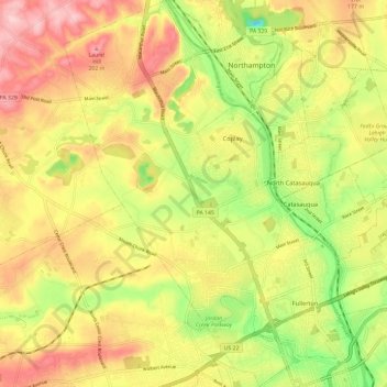
Name: Whitehall topographic map, elevation, terrain.
Location: Whitehall, Lehigh County, Pennsylvania, United States (40.61237 -75.54718 40.70223 -75.45954)
Average elevation: 400 ft
Minimum elevation: 49 ft
Maximum elevation: 712 ft
Lehigh County trails, hiking, mountain biking, running and outdoor activities
Other topographic maps
Click on a map to view its topography, its elevation and its terrain.
Hensingersville
United States > Pennsylvania > Lehigh County > Lower Macungie Township
Average elevation: 666 ft
Bake Oven Knob
United States > Pennsylvania > Lehigh County > Heidelberg Township
Average elevation: 1,017 ft
Walbert
United States > Pennsylvania > Lehigh County > South Whitehall Township
Average elevation: 449 ft
Crackersport
United States > Pennsylvania > Lehigh County > South Whitehall Township
Average elevation: 453 ft
Metamora Station
United States > Pennsylvania > Lehigh County > South Whitehall Township > Metamora Station
Average elevation: 410 ft
Old Zionsville
United States > Pennsylvania > Lehigh County > Upper Milford Township
Average elevation: 712 ft
Milford Park
United States > Pennsylvania > Lehigh County > Upper Milford Township
Average elevation: 725 ft
Laurys Station
United States > Pennsylvania > Lehigh County > North Whitehall Township
Average elevation: 499 ft
Neffs
United States > Pennsylvania > Lehigh County > North Whitehall Township
Average elevation: 682 ft