
Make a donation
Gear up for your next adventure:
As an Amazon Associate, this site earns from qualifying purchases at no extra cost to you.
Fortuna Foothills topographic map
Click on the map to display elevation.
Make a donation
Gear up for your next adventure:
As an Amazon Associate, this site earns from qualifying purchases at no extra cost to you.
About this map
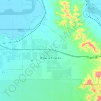
Name: Fortuna Foothills topographic map, elevation, terrain.
Location: Fortuna Foothills, Yuma County, Arizona, United States (32.61976 -114.49121 32.71813 -114.31699)
Average elevation: 436 ft
Minimum elevation: 141 ft
Maximum elevation: 2,287 ft
Yuma County trails, hiking, mountain biking, running and outdoor activities
Make a donation
Gear up for your next adventure:
As an Amazon Associate, this site earns from qualifying purchases at no extra cost to you.
Other topographic maps
Click on a map to view its topography, its elevation and its terrain.
Make a donation
Gear up for your next adventure:
As an Amazon Associate, this site earns from qualifying purchases at no extra cost to you.