
Make a donation
Gear up for your next adventure:
As an Amazon Associate, this site earns from qualifying purchases at no extra cost to you.
Tehri-Garhwal topographic map
Click on the map to display elevation.
Make a donation
Gear up for your next adventure:
As an Amazon Associate, this site earns from qualifying purchases at no extra cost to you.
About this map
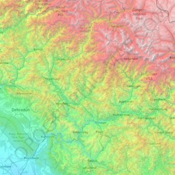
Name: Tehri-Garhwal topographic map, elevation, terrain.
Location: Tehri-Garhwal, Tehri Garhwal, Uttarakhand, 249125, India (29.80000 77.96667 31.20000 79.36667)
Average elevation: 7,674 ft
Minimum elevation: 797 ft
Maximum elevation: 23,314 ft
Make a donation
Gear up for your next adventure:
As an Amazon Associate, this site earns from qualifying purchases at no extra cost to you.
Other topographic maps
Click on a map to view its topography, its elevation and its terrain.
Pauri Garhwal
The mountains of Khirsu offer views of the northern Himalayas and attract a large number of tourists. Located 19 kilometres (12 mi) away from Pauri at an altitude of 1,700 metres (5,600 ft), Khirsu is peaceful and free from pollution. There is the nearby ancient temple of Ghandiyal Devta. Accommodation is…
Average elevation: 3,143 ft
Uttarakhand
Uttarakhand lies on the southern slope of the Himalaya range, and the climate and vegetation vary greatly with elevation, from glaciers at the highest elevations to subtropical forests at the lower elevations. The highest elevations are covered by ice and bare rock. Below them, between 3,000 and 5,000 metres…
Average elevation: 6,896 ft
Make a donation
Gear up for your next adventure:
As an Amazon Associate, this site earns from qualifying purchases at no extra cost to you.
Make a donation
Gear up for your next adventure:
As an Amazon Associate, this site earns from qualifying purchases at no extra cost to you.
Make a donation
Gear up for your next adventure:
As an Amazon Associate, this site earns from qualifying purchases at no extra cost to you.
Make a donation
Gear up for your next adventure:
As an Amazon Associate, this site earns from qualifying purchases at no extra cost to you.
Make a donation
Gear up for your next adventure:
As an Amazon Associate, this site earns from qualifying purchases at no extra cost to you.
Nainital
Nainital district is located in the Kumaon Himalaya. The district has part of the Bhabar tract in its south, which is bordered to the north by the Sivalik hills. To the north of this is the Lesser Himalayas, with a maximum altitude of 2600m. The main river in the district is the Kosi, which forms part of the…
Average elevation: 2,543 ft
Chamoli
The geology of the region shows that the Himalayas are amongst the youngest mountains in the world. During early Mesozoic times the land mass now covered by them was occupied by the great Tethys sea. The probable date of the commencement of the elevation of the Himalayas is about the close of the Mesozoic era,…
Average elevation: 12,178 ft
Make a donation
Gear up for your next adventure:
As an Amazon Associate, this site earns from qualifying purchases at no extra cost to you.
Rishikesh
Rishikesh is at 30°06′12″N 78°17′41″E / 30.103368°N 78.294754°E / 30.103368; 78.294754. It has an average elevation of 340 metres (1,120 ft). The town is located in the Tehri Garhwal region of the northern Indian state of Uttarakhand.
Average elevation: 2,651 ft
Make a donation
Gear up for your next adventure:
As an Amazon Associate, this site earns from qualifying purchases at no extra cost to you.
Pithoragarh district
The Bhotiya communities living in the Pithoragarh district historically practised transhumance between summer villages located at higher altitudes, close to the border with Tibet, and winter settlements located at lower altitudes, close to the Himalayan foothills and the Gangetic plains. With transhumance as a…
Average elevation: 11,591 ft
Make a donation
Gear up for your next adventure:
As an Amazon Associate, this site earns from qualifying purchases at no extra cost to you.
Make a donation
Gear up for your next adventure:
As an Amazon Associate, this site earns from qualifying purchases at no extra cost to you.
Kosi
The Kosi River catchment covers six geological and climatic belts varying in altitude from above 8,000 m (26,000 ft) to 95 m (312 ft) comprising the Tibetan plateau, the Himalayas, the Himalayan mid-hill belt, the Mahabharat Range, the Siwalik Hills and the Terai. The Dudh-Koshi sub-basin alone consists of 36…
Average elevation: 1,978 ft
Make a donation
Gear up for your next adventure:
As an Amazon Associate, this site earns from qualifying purchases at no extra cost to you.
Make a donation
Gear up for your next adventure:
As an Amazon Associate, this site earns from qualifying purchases at no extra cost to you.
Make a donation
Gear up for your next adventure:
As an Amazon Associate, this site earns from qualifying purchases at no extra cost to you.
Make a donation
Gear up for your next adventure:
As an Amazon Associate, this site earns from qualifying purchases at no extra cost to you.
Nainital
India > Uttarakhand > Nainital
Nainital is located in the Kumaon foothills of the outer Himalayas at a distance of 276 km (171 mi) from the state capital Dehradun and 314 km (195 mi) from New Delhi, the capital of India. Situated at an altitude of 1,938 metres (6,358 ft) above sea level, the town is set in a valley containing an eye-shaped…
Average elevation: 6,755 ft
Make a donation
Gear up for your next adventure:
As an Amazon Associate, this site earns from qualifying purchases at no extra cost to you.
Make a donation
Gear up for your next adventure:
As an Amazon Associate, this site earns from qualifying purchases at no extra cost to you.
Make a donation
Gear up for your next adventure:
As an Amazon Associate, this site earns from qualifying purchases at no extra cost to you.
Make a donation
Gear up for your next adventure:
As an Amazon Associate, this site earns from qualifying purchases at no extra cost to you.
Pindar
India > Uttarakhand > Tharali
The Pindar River is a river located in Uttarakhand, India. The Pindar originates from Pindari Glacier which is located in Bageshwar district of Kumaon region in Uttarakhand. The source of this river, the Pindar glacier is located at an altitude of 3,820 m (12,530 ft). Pindar glacier has relatively easier…
Average elevation: 8,310 ft
Roopkund Lake
India > Uttarakhand > Chamoli Tehsil
Roopkund (locally known as Mystery Lake or Skeleton Lake) is a high altitude glacial lake in the Uttarakhand state of India. It lies in the lap of Trishul massif. Located in the Himalayas, the area around the lake is uninhabited and is roughly at an altitude of 5,020 metres (16,470 ft), surrounded by…
Average elevation: 15,194 ft
Make a donation
Gear up for your next adventure:
As an Amazon Associate, this site earns from qualifying purchases at no extra cost to you.
Make a donation
Gear up for your next adventure:
As an Amazon Associate, this site earns from qualifying purchases at no extra cost to you.
Ramganga Dam
India > Uttarakhand > Kotdwara
The dam is a 128 m (420 ft) tall and 630 m (2,067 ft) long earth and rock-fill embankment dam with 10,000,000 m3 (13,079,506 cu yd) of fill. The dam's spillway is controlled by five gates and has a maximum discharge of 8,467 m3/s (299,009 cu ft/s). To support the reservoir's elevation, there is a 72 m (236 ft)…
Average elevation: 1,276 ft
Make a donation
Gear up for your next adventure:
As an Amazon Associate, this site earns from qualifying purchases at no extra cost to you.
Make a donation
Gear up for your next adventure:
As an Amazon Associate, this site earns from qualifying purchases at no extra cost to you.
Make a donation
Gear up for your next adventure:
As an Amazon Associate, this site earns from qualifying purchases at no extra cost to you.
Milam Glacier
India > Uttarakhand > Munsiari tehsil
Milam Glacier, covering around 37 km2 (14 sq mi) area of 16 km (10 mi) length, is located about 15 kilometres (9 mi) northeast of Nanda Devi. It ranges in elevation from about 5,500 metres (18,000 ft) to about 3,870 metres (12,700 ft) at its snout. Situated on the south facing slope of the main Great Himalayas…
Average elevation: 17,156 ft
Make a donation
Gear up for your next adventure:
As an Amazon Associate, this site earns from qualifying purchases at no extra cost to you.
Make a donation
Gear up for your next adventure:
As an Amazon Associate, this site earns from qualifying purchases at no extra cost to you.
Elephant Pound Rajaji National park Uttrakhand
India > Uttarakhand > Yamkeshwar
Average elevation: 1,493 ft
Make a donation
Gear up for your next adventure:
As an Amazon Associate, this site earns from qualifying purchases at no extra cost to you.