
Make a donation
Gear up for your next adventure:
As an Amazon Associate, this site earns from qualifying purchases at no extra cost to you.
Utebo topographic map
Click on the map to display elevation.
Make a donation
Gear up for your next adventure:
As an Amazon Associate, this site earns from qualifying purchases at no extra cost to you.
About this map
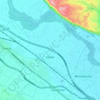
Name: Utebo topographic map, elevation, terrain.
Location: Utebo, Zaragoza, Aragón, 50180, España (41.69121 -1.04096 41.74468 -0.96608)
Average elevation: 722 ft
Minimum elevation: 646 ft
Maximum elevation: 1,263 ft
Make a donation
Gear up for your next adventure:
As an Amazon Associate, this site earns from qualifying purchases at no extra cost to you.
Other topographic maps
Click on a map to view its topography, its elevation and its terrain.
Make a donation
Gear up for your next adventure:
As an Amazon Associate, this site earns from qualifying purchases at no extra cost to you.
Ontinar de Salz
España > Aragón > Zaragoza > Zuera
Ontinar de Salz es una localidad española perteneciente al municipio de Zuera en la provincia de Zaragoza. Se encuentra a 34,8 km al norte de la ciudad de Zaragoza, capital de la provincia en la que está situado. Está a una altitud de 279 metros sobre el nivel del mar. Según el censo de 2022, esta…
Average elevation: 1,024 ft
Make a donation
Gear up for your next adventure:
As an Amazon Associate, this site earns from qualifying purchases at no extra cost to you.