
Pigeon Island topographic map
Interactive map
Click on the map to display elevation.
About this map
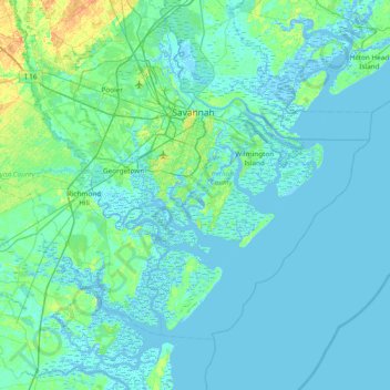
Name: Pigeon Island topographic map, elevation, terrain.
Location: Pigeon Island, Chatham County, Georgia, 31411, USA (31.62244 -81.40844 32.26244 -80.76844)
Average elevation: 13 ft
Minimum elevation: -16 ft
Maximum elevation: 115 ft
Other topographic maps
Click on a map to view its topography, its elevation and its terrain.
Alpharetta
USA > Georgia > Alpharetta
Alpharetta, Fulton County, Georgia, USA
Average elevation: 1,063 ft
Statesboro
USA > Georgia > Statesboro
Statesboro, Bulloch County, Georgia, USA
Average elevation: 217 ft
Chattahoochee Bend State Park
Chattahoochee Bend State Park, Coweta County, Georgia, USA
Average elevation: 781 ft
Orange Springs
USA > Georgia > Orange Springs
Orange Springs, Grady County, Georgia, 31797, USA
Average elevation: 256 ft
Cameron Point
USA > Georgia > Cameron Point
Cameron Point, Hall County, Georgia, 30506:30534, USA
Average elevation: 1,112 ft
Forbes Lake
USA > Georgia > Saint Louis
Forbes Lake, Dandelion Drive, Saint Louis, Macon County, Georgia, USA
Average elevation: 413 ft
Sandy Springs
USA > Georgia > Sandy Springs
Sandy Springs, Fulton County, Georgia, USA
Average elevation: 988 ft