
Morgan Heights topographic map
Click on the map to display elevation.
About this map
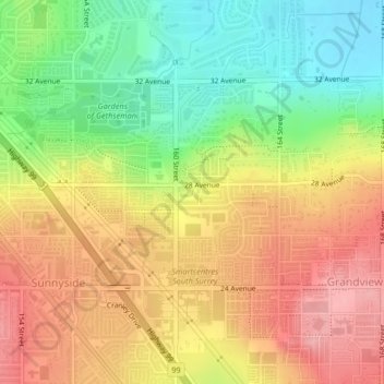
Name: Morgan Heights topographic map, elevation, terrain.
Average elevation: 200 ft
Minimum elevation: 0 ft
Maximum elevation: 381 ft
Other topographic maps
Click on a map to view its topography, its elevation and its terrain.
Surrey
Canada > British Columbia > Metro Vancouver Regional District > Surrey
Average elevation: 213 ft
Cloverdale
Canada > British Columbia > Metro Vancouver Regional District > Surrey
Average elevation: 79 ft
Newton
Canada > British Columbia > Metro Vancouver Regional District > Surrey
Average elevation: 157 ft
Serpentine Heights Park
Canada > British Columbia > Metro Vancouver Regional District > Surrey
Average elevation: 194 ft
Surrey Lake
Canada > British Columbia > Metro Vancouver Regional District > Surrey
Average elevation: 85 ft
South Surrey
Canada > British Columbia > Metro Vancouver Regional District > Surrey
Average elevation: 92 ft
Guildford
Canada > British Columbia > Metro Vancouver Regional District > Surrey
Average elevation: 151 ft
Surrey--Newton
Canada > British Columbia > Metro Vancouver Regional District > Surrey
Average elevation: 233 ft
Green Timbers Lake
Canada > British Columbia > Metro Vancouver Regional District > Surrey
Average elevation: 312 ft
Campbell Heights Biodiversity Preserve
Canada > British Columbia > Metro Vancouver Regional District > Surrey
Average elevation: 92 ft
South Surrey
Canada > British Columbia > Metro Vancouver Regional District > Surrey
Average elevation: 92 ft
Cresent Rock Beach
Canada > British Columbia > Metro Vancouver Regional District > Surrey
Average elevation: 95 ft
South Surrey
Canada > British Columbia > Metro Vancouver Regional District > Surrey
Average elevation: 92 ft