
Make a donation
Gear up for your next adventure:
As an Amazon Associate, this site earns from qualifying purchases at no extra cost to you.
Benamargosa topographic map
Click on the map to display elevation.
Make a donation
Gear up for your next adventure:
As an Amazon Associate, this site earns from qualifying purchases at no extra cost to you.
Benamargosa
Ubicado a 96 metros de altitud, en el valle del mismo nombre, su término municipal tiene una superficie de 12,12 km² y su población en 2016 es de 1.558 habitantes según el Instituto Nacional de Estadística (INE).
Make a donation
Gear up for your next adventure:
As an Amazon Associate, this site earns from qualifying purchases at no extra cost to you.
About this map
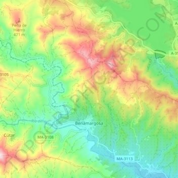
Name: Benamargosa topographic map, elevation, terrain.
Location: Benamargosa, La Axarquía, Málaga, Andalucía, 29718, España (36.81595 -4.21461 36.87861 -4.17756)
Average elevation: 843 ft
Minimum elevation: 187 ft
Maximum elevation: 1,913 ft
Make a donation
Gear up for your next adventure:
As an Amazon Associate, this site earns from qualifying purchases at no extra cost to you.
Other topographic maps
Click on a map to view its topography, its elevation and its terrain.
Lomilla del Albarcón
España > Andalucía > La Axarquía > Canillas de Aceituno
Average elevation: 2,657 ft
Make a donation
Gear up for your next adventure:
As an Amazon Associate, this site earns from qualifying purchases at no extra cost to you.
Make a donation
Gear up for your next adventure:
As an Amazon Associate, this site earns from qualifying purchases at no extra cost to you.
Lomas de Cútar
España > Andalucía > La Axarquía > Vélez-Málaga > La Zorrilla
Average elevation: 371 ft
Make a donation
Gear up for your next adventure:
As an Amazon Associate, this site earns from qualifying purchases at no extra cost to you.
Make a donation
Gear up for your next adventure:
As an Amazon Associate, this site earns from qualifying purchases at no extra cost to you.
Huerta de Gutiérrez
España > Andalucía > La Axarquía > Vélez-Málaga > Huerta de Gutiérrez
Average elevation: 751 ft
Urbanizacion La Esperanza
España > Andalucía > La Axarquía > Vélez-Málaga > Urbanizacion La Esperanza
Average elevation: 161 ft
Make a donation
Gear up for your next adventure:
As an Amazon Associate, this site earns from qualifying purchases at no extra cost to you.
Paraje Natural Acantilados de Maro-Cerro Gordo
España > Andalucía > La Axarquía > Nerja
Average elevation: 276 ft
Make a donation
Gear up for your next adventure:
As an Amazon Associate, this site earns from qualifying purchases at no extra cost to you.
Jardines Viña Málaga
España > Andalucía > La Axarquía > Vélez-Málaga > Torre del Mar
Average elevation: 36 ft