
Make a donation
Gear up for your next adventure:
As an Amazon Associate, this site earns from qualifying purchases at no extra cost to you.
Fitzwilliam topographic map
Click on the map to display elevation.
Make a donation
Gear up for your next adventure:
As an Amazon Associate, this site earns from qualifying purchases at no extra cost to you.
Fitzwilliam
According to the United States Census Bureau, the town has a total area of 36.0 square miles (93.3 km2), of which 34.6 square miles (89.7 km2) are land and 1.4 square miles (3.6 km2) are water, comprising 3.88% of the town. Little Monadnock Mountain, elevation 1,883 feet (574 m), is the highest point in Fitzwilliam, located in the western part of town. The Metacomet-Monadnock Trail traverses the summit, as does a shorter side trail from Rhododendron State Park. The town is drained by the South Branch of the Ashuelot River, the source of which is Bowker Pond. Fitzwilliam lies fully within the Connecticut River watershed.
Make a donation
Gear up for your next adventure:
As an Amazon Associate, this site earns from qualifying purchases at no extra cost to you.
About this map
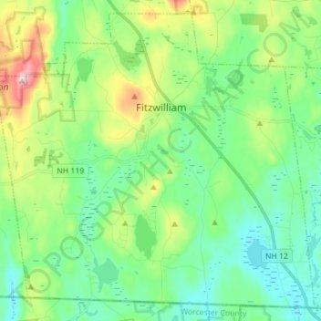
Name: Fitzwilliam topographic map, elevation, terrain.
Average elevation: 1,142 ft
Minimum elevation: 856 ft
Maximum elevation: 1,854 ft
Cheshire County trails, hiking, mountain biking, running and outdoor activities
Make a donation
Gear up for your next adventure:
As an Amazon Associate, this site earns from qualifying purchases at no extra cost to you.
Other topographic maps
Click on a map to view its topography, its elevation and its terrain.
West Chesterfield
United States > New Hampshire > Cheshire County > Chesterfield
Average elevation: 551 ft
Camp Notre Dame
United States > New Hampshire > Cheshire County > Chesterfield
Average elevation: 732 ft
Make a donation
Gear up for your next adventure:
As an Amazon Associate, this site earns from qualifying purchases at no extra cost to you.
Make a donation
Gear up for your next adventure:
As an Amazon Associate, this site earns from qualifying purchases at no extra cost to you.
Make a donation
Gear up for your next adventure:
As an Amazon Associate, this site earns from qualifying purchases at no extra cost to you.
Scotland
United States > New Hampshire > Cheshire County > Winchester > Scotland
Average elevation: 686 ft
Alstead Center
United States > New Hampshire > Cheshire County > Alstead > Alstead Center
Average elevation: 1,217 ft
Make a donation
Gear up for your next adventure:
As an Amazon Associate, this site earns from qualifying purchases at no extra cost to you.
Longmeadow Subdivision
United States > New Hampshire > Cheshire County > Keene
Average elevation: 587 ft