
Town of Sangerfield topographic map
Interactive map
Click on the map to display elevation.
About this map
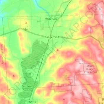
Name: Town of Sangerfield topographic map, elevation, terrain.
Location: Town of Sangerfield, Oneida County, New York, United States (42.86325 -75.44414 42.93541 -75.30789)
Average elevation: 1,430 ft
Minimum elevation: 951 ft
Maximum elevation: 1,946 ft
Other topographic maps
Click on a map to view its topography, its elevation and its terrain.
Brothertown
United States > New York > Oneida County > Town of Marshall
Brothertown, Town of Marshall, Oneida County, New York, 13328, United States
Average elevation: 1,115 ft
Town of Remsen
United States > New York > Oneida County
Town of Remsen, Oneida County, New York, United States
Average elevation: 1,283 ft
Village of Oriskany
United States > New York > Oneida County
Village of Oriskany, Town of Whitestown, Oneida County, New York, United States
Average elevation: 476 ft
Town of New Hartford
United States > New York > Oneida County
Town of New Hartford, Oneida County, New York, United States
Average elevation: 787 ft
Verona Beach
United States > New York > Oneida County > Town of Verona
Verona Beach, Town of Verona, Oneida County, New York, 13162, United States
Average elevation: 374 ft
Sauquoit
United States > New York > Oneida County > Town of Paris
Sauquoit, Town of Paris, Oneida County, New York, 13456, United States
Average elevation: 1,014 ft
Town of Boonville
United States > New York > Oneida County
Town of Boonville, Oneida County, New York, 13309, United States
Average elevation: 1,293 ft
Village of New York Mills
United States > New York > Oneida County
Village of New York Mills, Town of Whitestown, Oneida County, New York, 13417, United States
Average elevation: 505 ft
Town of Camden
United States > New York > Oneida County
Town of Camden, Oneida County, New York, 13316, United States
Average elevation: 702 ft
Village of Clayville
United States > New York > Oneida County
Village of Clayville, Town of Paris, Oneida County, New York, United States
Average elevation: 1,184 ft
Otter Lake
United States > New York > Oneida County > Town of Forestport
Otter Lake, Town of Forestport, Oneida County, New York, United States
Average elevation: 1,621 ft
Town of Annsville
United States > New York > Oneida County
Town of Annsville, Oneida County, New York, 13471, United States
Average elevation: 896 ft
Town of Lee
United States > New York > Oneida County
Town of Lee, Oneida County, New York, 13363, United States
Average elevation: 810 ft
Brookfield
United States > New York > Oneida County > Town of Lee
Brookfield, Town of Lee, Oneida County, New York, 13471, United States
Average elevation: 659 ft
Town of Marcy
United States > New York > Oneida County
Town of Marcy, Whitestown, Oneida County, New York, United States
Average elevation: 679 ft
Town of Kirkland
United States > New York > Oneida County
Town of Kirkland, Oneida County, New York, United States
Average elevation: 846 ft
Village of Camden
United States > New York > Oneida County
Village of Camden, Town of Camden, Oneida County, New York, United States
Average elevation: 551 ft
Town of Trenton
United States > New York > Oneida County
Town of Trenton, Oneida County, New York, United States
Average elevation: 909 ft
Washington Mills
United States > New York > Oneida County
Washington Mills, Town of New Hartford, Oneida County, New York, United States
Average elevation: 771 ft
White Lake
United States > New York > Oneida County > Town of Forestport
White Lake, Town of Forestport, Oneida County, New York, 13494, United States
Average elevation: 1,486 ft
Western
United States > New York > Oneida County
Western, Oneida County, New York, 13486, United States
Average elevation: 1,007 ft
City of Rome
United States > New York > Oneida County
City of Rome, Oneida County, New York, United States
Average elevation: 623 ft
Village of Clinton
United States > New York > Oneida County > Town of Kirkland
Village of Clinton, Town of Kirkland, Oneida County, New York, United States
Average elevation: 627 ft
Town of Forestport
United States > New York > Oneida County
Town of Forestport, Oneida County, New York, United States
Average elevation: 1,325 ft
Cassville
United States > New York > Oneida County > Town of Paris > Cassville
Cassville, Town of Paris, Oneida County, New York, 13318, United States
Average elevation: 1,358 ft
Blossvale
United States > New York > Oneida County > Town of Annsville > Blossvale
Blossvale, Town of Annsville, Oneida County, New York, 13401, United States
Average elevation: 482 ft
Ridge Mills
United States > New York > Oneida County > City of Rome > Ridge Mills
Ridge Mills, City of Rome, Oneida County, New York, 13440, United States
Average elevation: 499 ft
Town of Deerfield
United States > New York > Oneida County
Town of Deerfield, Oneida County, New York, United States
Average elevation: 938 ft
City of Utica
United States > New York > Oneida County
City of Utica, Oneida County, New York, United States
Average elevation: 600 ft
Town of Steuben
United States > New York > Oneida County
Town of Steuben, Oneida County, New York, United States
Average elevation: 1,224 ft
Westdale
United States > New York > Oneida County > Westdale
Westdale, Town of Camden, Oneida County, New York, 13483, United States
Average elevation: 627 ft
Stittville
United States > New York > Oneida County > Stittville
Stittville, Town of Marcy, Oneida County, New York, 13469, United States
Average elevation: 597 ft
White Lake
United States > New York > Oneida County
White Lake, Town of Forestport, Oneida County, New York, United States
Average elevation: 1,470 ft
Rome
United States > New York > Oneida County > City of Rome > Rome
Rome, City of Rome, Oneida County, New York, 13440-5621, United States
Average elevation: 469 ft