
Southland District topographic map
Interactive map
Click on the map to display elevation.
About this map
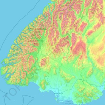
Name: Southland District topographic map, elevation, terrain.
Location: Southland District, Southland, New Zealand (-47.29000 166.42555 -44.25512 169.27947)
Average elevation: 1,040 ft
Minimum elevation: -7 ft
Maximum elevation: 8,796 ft
Other topographic maps
Click on a map to view its topography, its elevation and its terrain.
Sutherland Falls
New Zealand > Southland > Southland District > Fiordland Community
Sutherland Falls, Fiordland Community, Southland District, Southland, New Zealand
Average elevation: 3,301 ft
Mount Mackenzie
New Zealand > Southland > Southland District > Fiordland Community
Mount Mackenzie, Fiordland Community, Southland District, Southland, New Zealand
Average elevation: 3,839 ft
Milford Sound
New Zealand > Southland > Southland District > Fiordland Community
Milford Sound, Fiordland Community, Southland District, Southland, New Zealand
Average elevation: 2,149 ft
Stewart Island
Stewart Island, Southland, New Zealand
Average elevation: 207 ft
Oban
New Zealand > Southland > Southland District > Stewart Island / Rakiura Community
Oban, Stewart Island / Rakiura Community, Southland District, Southland, 9818, New Zealand
Average elevation: 75 ft
Turner Falls
New Zealand > Southland > Southland District > Fiordland Community
Turner Falls, Fiordland Community, Southland District, Southland, New Zealand
Average elevation: 4,380 ft
Invercargill City
Invercargill City, Southland, New Zealand
Average elevation: 36 ft
Bluff
New Zealand > Southland > Invercargill City
Bluff, Invercargill City, Southland, 9814, New Zealand
Average elevation: 36 ft
Misty River
New Zealand > Southland > Southland District > Fiordland Community
Misty River, Fiordland Community, Southland District, Southland, New Zealand
Average elevation: 1,240 ft
Manapouri
New Zealand > Southland > Southland District > Fiordland Community > Manapouri
Manapouri, Fiordland Community, Southland District, Southland, 7969, New Zealand
Average elevation: 699 ft
Te Anau
New Zealand > Southland > Southland District > Fiordland Community
Te Anau, Fiordland Community, Southland District, Southland, 9600, New Zealand
Average elevation: 817 ft