
Jiwangarh topographic map
Interactive map
Click on the map to display elevation.
About this map
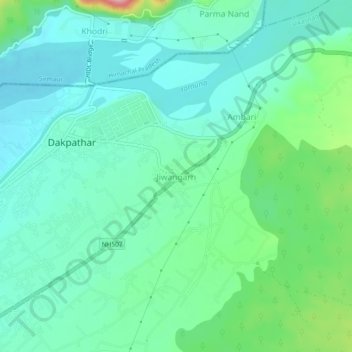
Name: Jiwangarh topographic map, elevation, terrain.
Location: Jiwangarh, Vikasnagar, Dehradun, Uttarakhand, 248198, India (30.47100 77.78669 30.51100 77.82669)
Average elevation: 1,581 ft
Minimum elevation: 1,460 ft
Maximum elevation: 1,982 ft
Other topographic maps
Click on a map to view its topography, its elevation and its terrain.
Masras
India > Uttarakhand > Vikasnagar
Masras, Vikasnagar, Dehradun District, Uttarakhand, India
Average elevation: 3,727 ft
Bidholi
India > Uttarakhand > Vikasnagar
Bidholi, Vikasnagar, Dehradun, Uttarakhand, 248007, India
Average elevation: 2,415 ft
Bhaūwāla
India > Uttarakhand > Vikasnagar
Bhaūwāla, Vikasnagar, Dehradun, Uttarakhand, India
Average elevation: 2,215 ft
Rājāwāla
India > Uttarakhand > Vikasnagar > Rājāwāla
Rājāwāla, Vikasnagar, Dehradun, Uttarakhand, 248011, India
Average elevation: 2,018 ft