Geolocate

Feitos topographic map

Click on the map to display elevation.

About this map

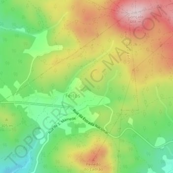
Name: Feitos topographic map, elevation, terrain.

Location: Feitos, Vila Cova e Feitos, Barcelos, Braga, Portugal (41.56393 -8.70711 41.58666 -8.67406)

Average elevation: 965 ft

Minimum elevation: 440 ft

Maximum elevation: 1,581 ft

Other topographic maps

Click on a map to view its topography, its elevation and its terrain.

Vila Cova

Portugal > Braga > Barcelos

Average elevation: 322 ft

Franqueira

Portugal > Braga > Barcelos

Average elevation: 479 ft

Silveiros

Portugal > Braga > Barcelos

Average elevation: 446 ft

Fonte Coberta

Portugal > Braga > Barcelos

Average elevation: 384 ft

Monte do Facho

Portugal > Braga > Barcelos > Roriz

Average elevation: 397 ft

Feitos

Portugal > Braga > Barcelos

Average elevation: 850 ft

Milhazes

Portugal > Braga > Barcelos

Average elevation: 272 ft

Vilar do Monte

Portugal > Braga > Barcelos

Average elevation: 541 ft

Gonçalo

Portugal > Braga > Barcelos

Average elevation: 1,138 ft

Martim de Além

Portugal > Braga > Barcelos > Martim

Average elevation: 440 ft

Durrães

Portugal > Braga > Barcelos

Average elevation: 433 ft

Gear up for your next adventure:

🌲Outdoor Survival Books - Best books on survival skills
🥄Camping Utensil Set - Lightweight utensils for outdoor meals
🛡️Insect Repellent - Protection against bugs during outdoor activities
🧥Men's Rain Shells - Premium waterproof and breathable jackets for mountain weather
🪓Survival Multi‑Tool - Versatile tool for camp and trail tasks

As an Amazon Associate, this site earns from qualifying purchases at no extra cost to you.