
Make a donation
Gear up for your next adventure:
As an Amazon Associate, this site earns from qualifying purchases at no extra cost to you.
Bürdenbach topographic map
Click on the map to display elevation.
Make a donation
Gear up for your next adventure:
As an Amazon Associate, this site earns from qualifying purchases at no extra cost to you.
About this map
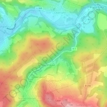
Name: Bürdenbach topographic map, elevation, terrain.
Average elevation: 768 ft
Minimum elevation: 535 ft
Maximum elevation: 1,070 ft
Make a donation
Gear up for your next adventure:
As an Amazon Associate, this site earns from qualifying purchases at no extra cost to you.
Other topographic maps
Click on a map to view its topography, its elevation and its terrain.
Hardberg
Deutschland > Rheinland-Pfalz > Landkreis Altenkirchen (Westerwald) > Schürdt
Average elevation: 814 ft
Oppertsau
Deutschland > Rheinland-Pfalz > Landkreis Altenkirchen (Westerwald)
Average elevation: 682 ft
Biersdorf
Deutschland > Rheinland-Pfalz > Landkreis Altenkirchen (Westerwald)
Average elevation: 1,184 ft
Wingendorf
Deutschland > Rheinland-Pfalz > Landkreis Altenkirchen (Westerwald)
Average elevation: 935 ft
Make a donation
Gear up for your next adventure:
As an Amazon Associate, this site earns from qualifying purchases at no extra cost to you.
Hollenstein
Deutschland > Rheinland-Pfalz > Landkreis Altenkirchen (Westerwald) > Friesenhagen
Average elevation: 1,079 ft
Sommerhof
Deutschland > Rheinland-Pfalz > Landkreis Altenkirchen (Westerwald) > Friesenhagen
Average elevation: 1,053 ft
Niederölfen
Deutschland > Rheinland-Pfalz > Landkreis Altenkirchen (Westerwald)
Average elevation: 804 ft
Heckerfeld
Deutschland > Rheinland-Pfalz > Landkreis Altenkirchen (Westerwald)
Average elevation: 787 ft
Make a donation
Gear up for your next adventure:
As an Amazon Associate, this site earns from qualifying purchases at no extra cost to you.
Aussichtspunkt
Deutschland > Rheinland-Pfalz > Landkreis Altenkirchen (Westerwald) > Selbach (Sieg)
Average elevation: 915 ft
Tüschebachsmühle
Deutschland > Rheinland-Pfalz > Landkreis Altenkirchen (Westerwald) > Fischbacherhütte
Average elevation: 961 ft
Kircheib
Deutschland > Rheinland-Pfalz > Landkreis Altenkirchen (Westerwald)
Die vermutlich erste urkundliche Erwähnung als Eipe (auch Eype) datiert aus dem Jahre 1268. Aus der gleichen Zeit sind eine kleine romanische Basilika und Reste der Motte Broichhausen, einer mittelalterlichen Fliehburg erhalten. Unterhalb Kircheibs bei Vierwinden grenzte die alte Grafschaft Sayn-Altenkirchen…
Average elevation: 922 ft
Make a donation
Gear up for your next adventure:
As an Amazon Associate, this site earns from qualifying purchases at no extra cost to you.
Herkersdorf
Deutschland > Rheinland-Pfalz > Landkreis Altenkirchen (Westerwald) > Kirchen (Sieg)
Average elevation: 984 ft
Dermbach
Deutschland > Rheinland-Pfalz > Landkreis Altenkirchen (Westerwald) > Herdorf
Dermbach liegt im geographischen Siegerland und an der Grenze zu Struthütten im historischen Siegerland. Der Ort liegt auf einer Höhe zwischen 280 und 340 m und hat eine Gemarkungsfläche von 4,41 km². Durchflossen wird er vom gleichnamigen Bach, der bei Herdorf in die Heller mündet. Die höchste Erhebung…
Average elevation: 1,171 ft
Mühlental
Deutschland > Rheinland-Pfalz > Landkreis Altenkirchen (Westerwald) > Breitscheidt
Average elevation: 699 ft
Auf dem Steimel
Deutschland > Rheinland-Pfalz > Landkreis Altenkirchen (Westerwald) > Giershausen
Average elevation: 873 ft
Make a donation
Gear up for your next adventure:
As an Amazon Associate, this site earns from qualifying purchases at no extra cost to you.
Streitholz
Deutschland > Rheinland-Pfalz > Landkreis Altenkirchen (Westerwald) > Wissen
Average elevation: 686 ft
Arsberg
Deutschland > Rheinland-Pfalz > Landkreis Altenkirchen (Westerwald) > Alsdorf
Average elevation: 1,010 ft
Bruchermühle
Deutschland > Rheinland-Pfalz > Landkreis Altenkirchen (Westerwald) > Bürdenbach
Average elevation: 768 ft
Fischbacherhütte
Deutschland > Rheinland-Pfalz > Landkreis Altenkirchen (Westerwald)
Average elevation: 978 ft
Make a donation
Gear up for your next adventure:
As an Amazon Associate, this site earns from qualifying purchases at no extra cost to you.
Altenbrendebach
Deutschland > Rheinland-Pfalz > Landkreis Altenkirchen (Westerwald) > Wissen
Average elevation: 896 ft
Oettershagen
Deutschland > Rheinland-Pfalz > Landkreis Altenkirchen (Westerwald)
Average elevation: 699 ft
Stegskopf
Deutschland > Rheinland-Pfalz > Landkreis Altenkirchen (Westerwald) > Emmerzhausen
Average elevation: 1,919 ft
Ahlbach
Deutschland > Rheinland-Pfalz > Landkreis Altenkirchen (Westerwald) > Flammersfeld
Average elevation: 823 ft
Make a donation
Gear up for your next adventure:
As an Amazon Associate, this site earns from qualifying purchases at no extra cost to you.
Altenkirchen
Deutschland > Rheinland-Pfalz > Landkreis Altenkirchen (Westerwald) > Altenkirchen (Westerwald)
Der Umzug der Karnevalsgesellschaft Altenkirchen 1972 e. V. am Karnevalssonntag, die Maifete am ersten Maiwochenende, das traditionelle Schützenfest der Altenkirchener Schützengesellschaft 1845 e. V. Anfang Juli oder das Oktoberfest gehören zu den Höhepunkten des Jahres.
Average elevation: 906 ft
Freusburg
Deutschland > Rheinland-Pfalz > Landkreis Altenkirchen (Westerwald)
Average elevation: 948 ft
Frankenthal
Deutschland > Rheinland-Pfalz > Landkreis Altenkirchen (Westerwald) > Wissen
Average elevation: 705 ft
Make a donation
Gear up for your next adventure:
As an Amazon Associate, this site earns from qualifying purchases at no extra cost to you.
Alsberg
Deutschland > Rheinland-Pfalz > Landkreis Altenkirchen (Westerwald) > Alsdorf
Average elevation: 1,027 ft
Fischbacherhütte
Deutschland > Rheinland-Pfalz > Landkreis Altenkirchen (Westerwald)
Average elevation: 978 ft
Hausen
Deutschland > Rheinland-Pfalz > Landkreis Altenkirchen (Westerwald) > Wissen > Glatteneichen
Average elevation: 751 ft
Make a donation
Gear up for your next adventure:
As an Amazon Associate, this site earns from qualifying purchases at no extra cost to you.