
Make a donation
Gear up for your next adventure:
As an Amazon Associate, this site earns from qualifying purchases at no extra cost to you.
Wenzhou topographic map
Click on the map to display elevation.
Make a donation
Gear up for your next adventure:
As an Amazon Associate, this site earns from qualifying purchases at no extra cost to you.
Wenzhou
Most of Wenzhou's landscape is mountainous, with many mountain tops reaching altitudes in excess of 1,000 m (3,300 ft), for example in the Yandang Mountains, a coastal mountain range dominating the eastern part of prefecture. Another dominating landscape element is the Ou River, the largest river in Wenzhou prefecture. There are some coastal plains, notably around the mouth of the Ou (where the city proper of Wenzhou is located), the Nanxi River, a tributary of the Ou, and further south, around the mouth of the Feiyun River (in Rui'an, a county-level city). Coastal plains are used intensively for agriculture but also host much of the population and industry.
Make a donation
Gear up for your next adventure:
As an Amazon Associate, this site earns from qualifying purchases at no extra cost to you.
About this map
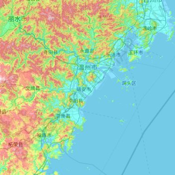
Name: Wenzhou topographic map, elevation, terrain.
Location: Wenzhou, Zhejiang, China (27.04494 119.62023 28.61525 121.83882)
Average elevation: 728 ft
Minimum elevation: -10 ft
Maximum elevation: 5,331 ft
Make a donation
Gear up for your next adventure:
As an Amazon Associate, this site earns from qualifying purchases at no extra cost to you.
Other topographic maps
Click on a map to view its topography, its elevation and its terrain.
Make a donation
Gear up for your next adventure:
As an Amazon Associate, this site earns from qualifying purchases at no extra cost to you.
Make a donation
Gear up for your next adventure:
As an Amazon Associate, this site earns from qualifying purchases at no extra cost to you.
Make a donation
Gear up for your next adventure:
As an Amazon Associate, this site earns from qualifying purchases at no extra cost to you.
Make a donation
Gear up for your next adventure:
As an Amazon Associate, this site earns from qualifying purchases at no extra cost to you.
Make a donation
Gear up for your next adventure:
As an Amazon Associate, this site earns from qualifying purchases at no extra cost to you.
Make a donation
Gear up for your next adventure:
As an Amazon Associate, this site earns from qualifying purchases at no extra cost to you.