Geolocate

Lewiston topographic map

Click on the map to display elevation.

About this map

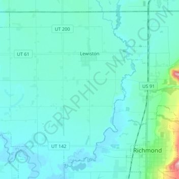
Name: Lewiston topographic map, elevation, terrain.

Location: Lewiston, Cache County, Utah, 84320, United States (41.91294 -111.94399 41.99878 -111.81197)

Average elevation: 4,514 ft

Minimum elevation: 4,419 ft

Maximum elevation: 5,328 ft

Cache County trails, hiking, mountain biking, running and outdoor activities

Other topographic maps

Click on a map to view its topography, its elevation and its terrain.

Mount Pisgah

United States > Utah > Cache County

Average elevation: 6,109 ft

Bald Head

United States > Utah > Cache County

Average elevation: 6,378 ft

Providence Canyon

United States > Utah > Cache County

Average elevation: 6,001 ft

Greenville

United States > Utah > Cache County > North Logan

Average elevation: 4,557 ft

Hyrum

United States > Utah > Cache County > Hyrum > Hyrum

Average elevation: 4,721 ft

Logan

United States > Utah > Cache County > Logan > Logan

Average elevation: 4,656 ft

Gear up for your next adventure:

🪶Fire Starter Kit - Reliable fire starter for survival and camping
🔊Portable Camp Speaker - Music and alerts at camp
🎒Hydration Pack - Hands‑free water reservoir for long hikes
🪓Survival Multi‑Tool - Versatile tool for camp and trail tasks
🏥Hiking First Aid Kits - Comprehensive medical kits for remote trail injuries

As an Amazon Associate, this site earns from qualifying purchases at no extra cost to you.