
Make a donation
Gear up for your next adventure:
As an Amazon Associate, this site earns from qualifying purchases at no extra cost to you.
Madikwe Game Reserve topographic map
Click on the map to display elevation.
Make a donation
Gear up for your next adventure:
As an Amazon Associate, this site earns from qualifying purchases at no extra cost to you.
About this map
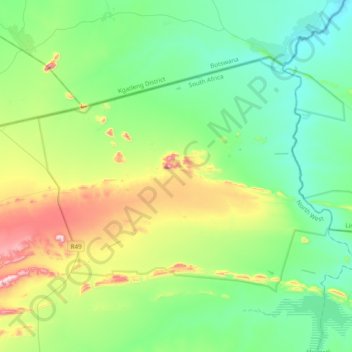
Name: Madikwe Game Reserve topographic map, elevation, terrain.
Average elevation: 3,360 ft
Minimum elevation: 2,969 ft
Maximum elevation: 4,465 ft
Make a donation
Gear up for your next adventure:
As an Amazon Associate, this site earns from qualifying purchases at no extra cost to you.
Other topographic maps
Click on a map to view its topography, its elevation and its terrain.
Mahikeng
South Africa > North West > Ngaka Modiri Molema District Municipality
Close to South Africa's border with Botswana, Mafikeng is 1,400 km (870 mi) northeast of Cape Town and 260 km (160 mi) west of Johannesburg. In 2001 it had a population of 49,300. In 2007 Mafikeng was reported to have a population of 250,000, of which the CBD constituted between 69,000 and 75,000. It is built…
Average elevation: 4,334 ft
Coligny
South Africa > North West > Ngaka Modiri Molema District Municipality > Ditsobotla Local Municipality
Average elevation: 4,846 ft
Groot-Marico
South Africa > North West > Ngaka Modiri Molema District Municipality > Ramotshere Moiloa Local Municipality
The topography comprises dry bushveld with a climate that is ideal for cattle, maize, citrus fruit and tobacco. Open pit quarries in the area extract marble, slate and andalusite, with prospects of large-scale nickel mining on the banks of the Groot Marico river as well as the majority of the farms surrounding…
Average elevation: 3,757 ft
Make a donation
Gear up for your next adventure:
As an Amazon Associate, this site earns from qualifying purchases at no extra cost to you.
Atamelang
South Africa > North West > Ngaka Modiri Molema District Municipality > Tswaing Local Municipality
Average elevation: 4,564 ft
Taolelo
South Africa > North West > Ngaka Modiri Molema District Municipality > Mahikeng Local Municipality
Average elevation: 4,049 ft
Lichtenburg
South Africa > North West > Ngaka Modiri Molema District Municipality > Ditsobotla Local Municipality
Average elevation: 4,856 ft
Ottosdal
South Africa > North West > Ngaka Modiri Molema District Municipality > Tswaing Local Municipality
Ottosdal is a small town situated at an altitude of 1,479 meters (4,855 feet) on the branch railway line from Makwassie in the central North West Province of South Africa. Ottosdal is a farming community engaged in the growing of grains such as maize (mielies), sunflower and peanuts. In addition, local farmers…
Average elevation: 4,892 ft
Make a donation
Gear up for your next adventure:
As an Amazon Associate, this site earns from qualifying purchases at no extra cost to you.
Marico-Bosveld Dam
South Africa > North West > Ngaka Modiri Molema District Municipality > Ramotshere Moiloa Local Municipality
Average elevation: 3,501 ft
Ottosdal
South Africa > North West > Ngaka Modiri Molema District Municipality > Tswaing Local Municipality
Ottosdal is a small town situated at an altitude of 1,479 meters (4,855 feet) on the branch railway line from Makwassie in the central North West Province of South Africa. Ottosdal is a farming community engaged in the growing of grains such as maize (mielies), sunflower and peanuts. In addition, local farmers…
Average elevation: 4,892 ft
Mahikeng
South Africa > North West > Ngaka Modiri Molema District Municipality
Close to South Africa's border with Botswana, Mafikeng is 1,400 km (870 mi) northeast of Cape Town and 260 km (160 mi) west of Johannesburg. In 2001 it had a population of 49,300. In 2007 Mafikeng was reported to have a population of 250,000, of which the CBD constituted between 69,000 and 75,000. It is built…
Average elevation: 4,334 ft
Lichtenburg
South Africa > North West > Ngaka Modiri Molema District Municipality > Ditsobotla Local Municipality
Average elevation: 4,856 ft
Make a donation
Gear up for your next adventure:
As an Amazon Associate, this site earns from qualifying purchases at no extra cost to you.
Itsoseng
South Africa > North West > Ngaka Modiri Molema District Municipality > Ditsobotla Local Municipality
Average elevation: 4,879 ft
Lichtenburg
South Africa > North West > Ngaka Modiri Molema District Municipality > Ditsobotla Local Municipality
Average elevation: 4,856 ft
Libertas
South Africa > North West > Ngaka Modiri Molema District Municipality > Mahikeng Local Municipality
Average elevation: 4,216 ft
Lotlamoreng Dam
South Africa > North West > Ngaka Modiri Molema District Municipality > Mahikeng Local Municipality > Seweding
Average elevation: 4,121 ft
Make a donation
Gear up for your next adventure:
As an Amazon Associate, this site earns from qualifying purchases at no extra cost to you.
Mahikeng
South Africa > North West > Ngaka Modiri Molema District Municipality
Close to South Africa's border with Botswana, Mafikeng is 1,400 km (870 mi) northeast of Cape Town and 260 km (160 mi) west of Johannesburg. In 2001 it had a population of 49,300. In 2007 Mafikeng was reported to have a population of 250,000, of which the CBD constituted between 69,000 and 75,000. It is built…
Average elevation: 4,334 ft