Geolocate

Cowan topographic map

Click on the map to display elevation.

About this map

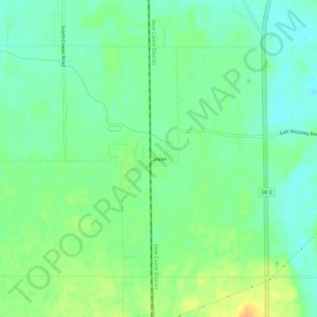
Name: Cowan topographic map, elevation, terrain.

Location: Cowan, Delaware County, Indiana, 47367, United States (40.08588 -85.40858 40.12588 -85.36858)

Average elevation: 994 ft

Minimum elevation: 951 ft

Maximum elevation: 1,056 ft

Delaware County trails, hiking, mountain biking, running and outdoor activities

Other topographic maps

Click on a map to view its topography, its elevation and its terrain.

Yorktown

United States > Indiana > Delaware County

Average elevation: 925 ft

Eaton

United States > Indiana > Delaware County

Average elevation: 915 ft

Albany

United States > Indiana > Delaware County

Average elevation: 951 ft

White River

United States > Indiana > Delaware County > Yorktown

Average elevation: 925 ft

Daleville

United States > Indiana > Delaware County

Average elevation: 919 ft

Selma

United States > Indiana > Delaware County

Average elevation: 997 ft

Gear up for your next adventure:

🪶Camping Sleeping Pad - Comfortable sleeping pad for backpacking
🏥Hiking First Aid Kits - Comprehensive medical kits for remote trail injuries
🪶Compact Camp Shovel - Folding shovel for campsite tasks
📦Gear Storage Bags - Organize and protect outdoor equipment
🔥Fast-Boil Camping Stoves - Efficient cooking systems for quick trail meals

As an Amazon Associate, this site earns from qualifying purchases at no extra cost to you.