
Make a donation
Gear up for your next adventure:
As an Amazon Associate, this site earns from qualifying purchases at no extra cost to you.
Pittston Township topographic map
Click on the map to display elevation.
Make a donation
Gear up for your next adventure:
As an Amazon Associate, this site earns from qualifying purchases at no extra cost to you.
Pittston Township
According to the United States Census Bureau, the township has a total area of 13.79 square miles (35.71 km2), of which 13.77 square miles (35.66 km2) is land and 0.02 square miles (0.05 km2), or 0.15%, is water. It is the second largest community by area in Greater Pittston. The township is served by the Pittston Area School District. The eastern part of the township is made up of mountains and forests. Most of the township's residents and businesses are located in the western half of the town. The elevation ranges from 2,130 feet (650 m) above sea level at the summit of Little Shiney Mountain in the southeastern corner of the township to 630 feet (190 m) in several valleys along the western border, near the Susquehanna River.
Make a donation
Gear up for your next adventure:
As an Amazon Associate, this site earns from qualifying purchases at no extra cost to you.
About this map
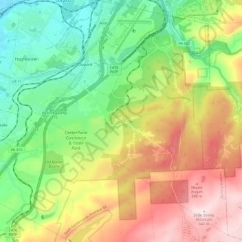
Name: Pittston Township topographic map, elevation, terrain.
Average elevation: 1,220 ft
Minimum elevation: 545 ft
Maximum elevation: 2,123 ft
Luzerne County trails, hiking, mountain biking, running and outdoor activities
Make a donation
Gear up for your next adventure:
As an Amazon Associate, this site earns from qualifying purchases at no extra cost to you.
Other topographic maps
Click on a map to view its topography, its elevation and its terrain.
Lake Leigh Dam (defunct)
United States > Pennsylvania > Luzerne County > Fairmount Township
Average elevation: 2,205 ft
Stairville
United States > Pennsylvania > Luzerne County > Dorrance Township
Average elevation: 1,089 ft
Solomon Gap
United States > Pennsylvania > Luzerne County > Fairview Township > Fairview
Average elevation: 1,572 ft
Make a donation
Gear up for your next adventure:
As an Amazon Associate, this site earns from qualifying purchases at no extra cost to you.
Georgetown
United States > Pennsylvania > Luzerne County > Wilkes-Barre Township
Average elevation: 876 ft
Wech Corners
United States > Pennsylvania > Luzerne County > Wright Township
Average elevation: 1,375 ft
Make a donation
Gear up for your next adventure:
As an Amazon Associate, this site earns from qualifying purchases at no extra cost to you.
Natural Lands Trust Bear Creek Preserve - Dry Land Hill Parcel
United States > Pennsylvania > Luzerne County > Shades Glen
Average elevation: 1,663 ft
Trucksville
United States > Pennsylvania > Luzerne County > Kingston Township
Average elevation: 1,125 ft
Make a donation
Gear up for your next adventure:
As an Amazon Associate, this site earns from qualifying purchases at no extra cost to you.
Truesdale Terrace
United States > Pennsylvania > Luzerne County > Hanover Township
Average elevation: 1,047 ft
Make a donation
Gear up for your next adventure:
As an Amazon Associate, this site earns from qualifying purchases at no extra cost to you.
Lower Askam
United States > Pennsylvania > Luzerne County > Hanover Township
Average elevation: 719 ft
Make a donation
Gear up for your next adventure:
As an Amazon Associate, this site earns from qualifying purchases at no extra cost to you.
Port Bowkley
United States > Pennsylvania > Luzerne County > Plains Township > Plains
Average elevation: 581 ft
Nescopeck Pass
United States > Pennsylvania > Luzerne County > Nescopeck Pass
Average elevation: 1,401 ft
Make a donation
Gear up for your next adventure:
As an Amazon Associate, this site earns from qualifying purchases at no extra cost to you.
West Nanticoke
United States > Pennsylvania > Luzerne County > West Nanticoke
Average elevation: 909 ft
Scouton Lee Park
United States > Pennsylvania > Luzerne County > Wilkes-Barre > Parsons
Average elevation: 630 ft
Make a donation
Gear up for your next adventure:
As an Amazon Associate, this site earns from qualifying purchases at no extra cost to you.
Huntington Creek
United States > Pennsylvania > Luzerne County > Pleasant Valley
Average elevation: 1,010 ft
South Pond Dam
United States > Pennsylvania > Luzerne County > Hanover Township
Average elevation: 669 ft
Make a donation
Gear up for your next adventure:
As an Amazon Associate, this site earns from qualifying purchases at no extra cost to you.