
Slocum topographic map
Click on the map to display elevation.
About this map
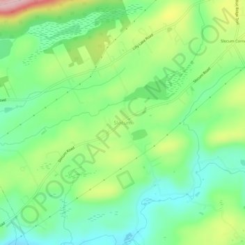
Name: Slocum topographic map, elevation, terrain.
Location: Slocum, Luzerne County, Pennsylvania, 18660, United States (41.11203 -76.06576 41.15203 -76.02576)
Average elevation: 1,070 ft
Minimum elevation: 830 ft
Maximum elevation: 1,512 ft
Luzerne County trails, hiking, mountain biking, running and outdoor activities
Other topographic maps
Click on a map to view its topography, its elevation and its terrain.
Pittston Township
United States > Pennsylvania > Luzerne County
According to the United States Census Bureau, the township has a total area of 13.79 square miles (35.71 km2), of which 13.77 square miles (35.66 km2) is land and 0.02 square miles (0.05 km2), or 0.15%, is water. It is the second largest community by area in Greater Pittston. The township is served by the…
Average elevation: 1,220 ft
Lake Leigh Dam (defunct)
United States > Pennsylvania > Luzerne County > Fairmount Township
Average elevation: 2,205 ft
Ricketts Glen State Park
United States > Pennsylvania > Luzerne County > Fairmount Township
The state's original plans for the new park included building an inn, an 18-hole golf course and country club, and a winter sports complex for skiing, ice boating, and tobogganing, as well as a beach with bathing facilities, cabins, and a tent camping area. Only the last three were actually built, all south of…
Average elevation: 1,929 ft
Scouton Lee Park
United States > Pennsylvania > Luzerne County > Wilkes-Barre > Parsons
Average elevation: 630 ft
Huntington Creek
United States > Pennsylvania > Luzerne County > Pleasant Valley
Average elevation: 1,010 ft
Natural Lands Trust Bear Creek Preserve - Dry Land Hill Parcel
United States > Pennsylvania > Luzerne County > Shades Glen
Average elevation: 1,663 ft