
Make a donation
Gear up for your next adventure:
As an Amazon Associate, this site earns from qualifying purchases at no extra cost to you.
Bonneauville topographic map
Click on the map to display elevation.
Make a donation
Gear up for your next adventure:
As an Amazon Associate, this site earns from qualifying purchases at no extra cost to you.
About this map
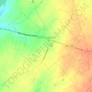
Name: Bonneauville topographic map, elevation, terrain.
Location: Bonneauville, Adams County, Pennsylvania, United States (39.80037 -77.15376 39.82018 -77.12111)
Average elevation: 591 ft
Minimum elevation: 495 ft
Maximum elevation: 646 ft
Adams County trails, hiking, mountain biking, running and outdoor activities
Make a donation
Gear up for your next adventure:
As an Amazon Associate, this site earns from qualifying purchases at no extra cost to you.
Other topographic maps
Click on a map to view its topography, its elevation and its terrain.
Wenksville
United States > Pennsylvania > Adams County > Menallen Township
Average elevation: 1,178 ft
Tartown
United States > Pennsylvania > Adams County > Hamiltonban Township
Average elevation: 1,483 ft
Two Taverns
United States > Pennsylvania > Adams County > Mount Joy Township
Average elevation: 548 ft
Make a donation
Gear up for your next adventure:
As an Amazon Associate, this site earns from qualifying purchases at no extra cost to you.
Iron Springs
United States > Pennsylvania > Adams County > Hamiltonban Township
Average elevation: 866 ft
Make a donation
Gear up for your next adventure:
As an Amazon Associate, this site earns from qualifying purchases at no extra cost to you.
Maria Furnace
United States > Pennsylvania > Adams County > Hamiltonban Township
Average elevation: 955 ft
Mount Tabor
United States > Pennsylvania > Adams County > Menallen Township
Average elevation: 1,001 ft
Make a donation
Gear up for your next adventure:
As an Amazon Associate, this site earns from qualifying purchases at no extra cost to you.
Bermudian Creek
United States > Pennsylvania > Adams County > Latimore Township
Average elevation: 545 ft
Graefenburg
United States > Pennsylvania > Adams County > Franklin Township
Average elevation: 1,283 ft
Make a donation
Gear up for your next adventure:
As an Amazon Associate, this site earns from qualifying purchases at no extra cost to you.
Greenmount
United States > Pennsylvania > Adams County > Cumberland Township
Average elevation: 495 ft
McKnightstown
United States > Pennsylvania > Adams County > Franklin Township
Average elevation: 633 ft
Make a donation
Gear up for your next adventure:
As an Amazon Associate, this site earns from qualifying purchases at no extra cost to you.
Cress Ridge
United States > Pennsylvania > Adams County > Mount Pleasant Township
Average elevation: 581 ft
Mount Hope
United States > Pennsylvania > Adams County > Hamiltonban Township
Average elevation: 1,296 ft
Make a donation
Gear up for your next adventure:
As an Amazon Associate, this site earns from qualifying purchases at no extra cost to you.
Cemetery Ridge
United States > Pennsylvania > Adams County > Cumberland Township
Average elevation: 545 ft
Make a donation
Gear up for your next adventure:
As an Amazon Associate, this site earns from qualifying purchases at no extra cost to you.