
Make a donation
Gear up for your next adventure:
As an Amazon Associate, this site earns from qualifying purchases at no extra cost to you.
Lahr topographic map
Click on the map to display elevation.
Make a donation
Gear up for your next adventure:
As an Amazon Associate, this site earns from qualifying purchases at no extra cost to you.
About this map
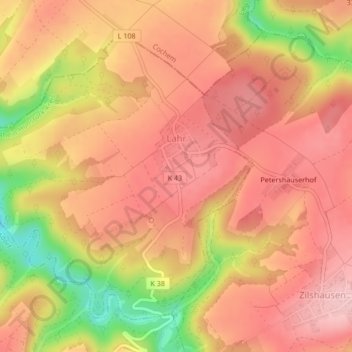
Name: Lahr topographic map, elevation, terrain.
Average elevation: 1,024 ft
Minimum elevation: 630 ft
Maximum elevation: 1,217 ft
Make a donation
Gear up for your next adventure:
As an Amazon Associate, this site earns from qualifying purchases at no extra cost to you.
Other topographic maps
Click on a map to view its topography, its elevation and its terrain.
Rheinbay
Deutschland > Rheinland-Pfalz > Rhein-Hunsrück-Kreis > Boppard > Hirzenach > Rheinbay
Average elevation: 1,148 ft
Biebernheim
Deutschland > Rheinland-Pfalz > Rhein-Hunsrück-Kreis > Sankt Goar
Biebernheim ist ein Stadtteil von Sankt Goar im Rhein-Hunsrück-Kreis in Rheinland-Pfalz. Das Rheinhöhendorf liegt unmittelbar am Steilhang zum Rheintal auf der linken Rheinseite. Biebernheim war bis zum 7. Juni 1969 eine eigenständige Gemeinde, die dann im Rahmen einer Verwaltungsreform aufgelöst und in…
Average elevation: 702 ft
Salzbornhöhe
Deutschland > Rheinland-Pfalz > Rhein-Hunsrück-Kreis > Boppard > Weiler
Average elevation: 794 ft
Make a donation
Gear up for your next adventure:
As an Amazon Associate, this site earns from qualifying purchases at no extra cost to you.
Buchholz
Deutschland > Rheinland-Pfalz > Rhein-Hunsrück-Kreis > Boppard
Buchholz ist seit 1976 der zweitgrößte Ortsbezirk der Stadt Boppard. Die Ortslage liegt auf den Hunsrückhöhen an der Wasserscheide zwischen Rhein und Mosel.
Average elevation: 1,158 ft
Schanzerkopf
Deutschland > Rheinland-Pfalz > Rhein-Hunsrück-Kreis > Argenthal
Average elevation: 1,798 ft
Waldsiedlung Römerstraße
Deutschland > Rheinland-Pfalz > Rhein-Hunsrück-Kreis > Rheinböllen
Average elevation: 1,447 ft
Steffenshof
Deutschland > Rheinland-Pfalz > Rhein-Hunsrück-Kreis > Dorweiler
Average elevation: 1,129 ft
Make a donation
Gear up for your next adventure:
As an Amazon Associate, this site earns from qualifying purchases at no extra cost to you.
Dellhofen
Deutschland > Rheinland-Pfalz > Rhein-Hunsrück-Kreis > Oberwesel
Das Rheinhöhendorf Dellhofen ist ein Stadtteil und ein Ortsbezirk der Stadt Oberwesel im Rhein-Hunsrück-Kreis in Rheinland-Pfalz.
Average elevation: 896 ft
Wohnroth
Deutschland > Rheinland-Pfalz > Rhein-Hunsrück-Kreis
Die Ortschaft Wohnroth, im örtlichen Dialekt Woord, liegt in einer Hanglage am Beginn des Wohnrother Tales, das an der Burg Balduinseck endet. Der Ort kann nur über Land- und Kreisstraßen von der ca. 5 km entfernten Hunsrückhöhenstraße erreicht werden.
Average elevation: 1,325 ft
Werlauer Pilz
Deutschland > Rheinland-Pfalz > Rhein-Hunsrück-Kreis > Sankt Goar > Biebernheim
Average elevation: 558 ft
Make a donation
Gear up for your next adventure:
As an Amazon Associate, this site earns from qualifying purchases at no extra cost to you.
Fleckertshöhe
Deutschland > Rheinland-Pfalz > Rhein-Hunsrück-Kreis > Boppard
Fleckertshöhe von Nordosten
Average elevation: 1,355 ft
Werlau
Deutschland > Rheinland-Pfalz > Rhein-Hunsrück-Kreis > Sankt Goar
Werlau ist ein Stadtteil von Sankt Goar im Rhein-Hunsrück-Kreis in Rheinland-Pfalz. Das Rheinhöhendorf liegt unmittelbar am Steilhang zum Rheintal auf der linken Rheinseite. Der Ort hat etwa 820 Einwohner. Werlau war bis zum 7. Juni 1969 eine eigenständige Gemeinde, die dann im Rahmen einer…
Average elevation: 692 ft
St. Goar-Fellen
Deutschland > Rheinland-Pfalz > Rhein-Hunsrück-Kreis > Sankt Goar
Average elevation: 682 ft
Schmiedel
Deutschland > Rheinland-Pfalz > Rhein-Hunsrück-Kreis > Nannhausen
Average elevation: 1,201 ft
Make a donation
Gear up for your next adventure:
As an Amazon Associate, this site earns from qualifying purchases at no extra cost to you.
Langscheid
Deutschland > Rheinland-Pfalz > Rhein-Hunsrück-Kreis > Oberwesel
Über die Jahrhunderte variierte der Ortsname leicht – es finden sich nach der ersten Erwähnung 1253 als in Langesceider bach noch verschiedene Abwandlungen, bis im Jahr 1788 erstmals das heutige „Langscheid“ erscheint. Der Ortsname leitet sich von mittelhochdeutsch langen scheit = „beim langen…
Average elevation: 863 ft
Holzfeld
Deutschland > Rheinland-Pfalz > Rhein-Hunsrück-Kreis > Boppard > Holzfeld
Der Name des Ortes stammt aus dem mittelhochdeutsch: Hals = fortlaufende schmale Höhe. Somit leitet sich der Name Holzfeld von der geographischen Lage ab.
Average elevation: 928 ft
Schnellbach
Deutschland > Rheinland-Pfalz > Rhein-Hunsrück-Kreis > Schnellbach
Average elevation: 1,388 ft
Salzbornhöhe
Deutschland > Rheinland-Pfalz > Rhein-Hunsrück-Kreis > Boppard > Weiler
Average elevation: 794 ft
Make a donation
Gear up for your next adventure:
As an Amazon Associate, this site earns from qualifying purchases at no extra cost to you.