Geolocate

Quingeo topographic map

Click on the map to display elevation.

👉 Easily get elevation data in JSON, GeoTIFF and KML formats using Elevation API
Thank you for supporting this site ❤️
Make a donation

About this map

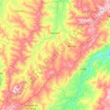
Name: Quingeo topographic map, elevation, terrain.

Location: Quingeo, Cuenca, Azuay, Ecuador (-3.13866 -79.00361 -2.98502 -78.87623)

Average elevation: 9,514 ft

Minimum elevation: 7,884 ft

Maximum elevation: 10,896 ft

Other topographic maps

Click on a map to view its topography, its elevation and its terrain.

Cochapamba Grande

Ecuador > Azuay > Cuenca > Quingeo

Average elevation: 9,163 ft

Soldados

Ecuador > Azuay > Cuenca > San Joaquín

Average elevation: 11,719 ft

Ricaurte

Ecuador > Azuay > Cuenca > Cuenca > Ricaurte

Average elevation: 8,281 ft

Gear up for your next adventure:

📱Heavy-Duty Phone Cases - Drop-proof and waterproof protection for outdoor navigation
🥾Hiking Shoes - Durable and comfortable shoes for trail hiking
🪶Camp Gear Gift Set - Perfect gift bundle for outdoor fans
📷Action Cameras - Rugged cameras to document your journeys across rugged terrain
🔥Camping Stove - Portable stove for camping and backcountry cooking

As an Amazon Associate, this site earns from qualifying purchases at no extra cost to you.