
Sandyville topographic map
Click on the map to display elevation.
About this map
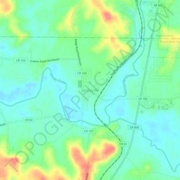
Name: Sandyville topographic map, elevation, terrain.
Location: Sandyville, Tuscarawas County, Ohio, 44671, United States (40.62069 -81.39065 40.66069 -81.35065)
Average elevation: 981 ft
Minimum elevation: 902 ft
Maximum elevation: 1,168 ft
Tuscarawas County trails, hiking, mountain biking, running and outdoor activities
Other topographic maps
Click on a map to view its topography, its elevation and its terrain.