
Stratford topographic map
Click on the map to display elevation.
Stratford
According to the United States Census Bureau, the town has a total area of 19.9 square miles (52 km2), of which 17.6 square miles (46 km2) is land and 2.3 square miles (6.0 km2), or 11.52%, is water. Stratford has a minimum elevation of zero feet above sea level along its coastline, with a maximum altitude of 295 feet (90 m) near its northern border, and an average elevation of 23 feet (7.0 m).
About this map
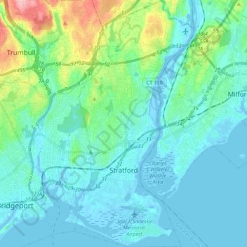
Name: Stratford topographic map, elevation, terrain.
Average elevation: 82 ft
Minimum elevation: -26 ft
Maximum elevation: 489 ft
Greater Bridgeport Planning Region trails, hiking, mountain biking, running and outdoor activities
Other topographic maps
Click on a map to view its topography, its elevation and its terrain.
Oronoque
United States > Connecticut > Greater Bridgeport Planning Region > Stratford
Average elevation: 121 ft
Southport
United States > Connecticut > Greater Bridgeport Planning Region > Fairfield
Average elevation: 36 ft
Stepney
United States > Connecticut > Greater Bridgeport Planning Region > Monroe
Average elevation: 404 ft
Greenfield Hill
United States > Connecticut > Greater Bridgeport Planning Region > Fairfield
Average elevation: 174 ft
Melville Village
United States > Connecticut > Greater Bridgeport Planning Region > Fairfield > Stratfield
Average elevation: 128 ft
Powells Hill
United States > Connecticut > Greater Bridgeport Planning Region > Easton
Average elevation: 285 ft
Long Hill
United States > Connecticut > Greater Bridgeport Planning Region > Trumbull
Average elevation: 384 ft
Barn Hill
United States > Connecticut > Greater Bridgeport Planning Region > Monroe
Average elevation: 479 ft
Long Hill
United States > Connecticut > Greater Bridgeport Planning Region > Trumbull
Average elevation: 384 ft
Stratfield
United States > Connecticut > Greater Bridgeport Planning Region > Fairfield
Average elevation: 174 ft
Lordship Beach
United States > Connecticut > Greater Bridgeport Planning Region > Stratford > Lordship
Average elevation: 3 ft