Geolocate

Lama topographic map

Click on the map to display elevation.

About this map

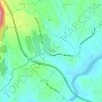
Name: Lama topographic map, elevation, terrain.

Location: Lama, Barcelos, Braga, 4750-513, Portugal (41.55993 -8.56300 41.57801 -8.52528)

Average elevation: 190 ft

Minimum elevation: 49 ft

Maximum elevation: 663 ft

Other topographic maps

Click on a map to view its topography, its elevation and its terrain.

Vila Cova

Portugal > Braga > Barcelos

Average elevation: 322 ft

Franqueira

Portugal > Braga > Barcelos

Average elevation: 479 ft

Silveiros

Portugal > Braga > Barcelos

Average elevation: 446 ft

Fonte Coberta

Portugal > Braga > Barcelos

Average elevation: 384 ft

Monte do Facho

Portugal > Braga > Barcelos > Roriz

Average elevation: 397 ft

Feitos

Portugal > Braga > Barcelos

Average elevation: 850 ft

Milhazes

Portugal > Braga > Barcelos

Average elevation: 272 ft

Vilar do Monte

Portugal > Braga > Barcelos

Average elevation: 541 ft

Gonçalo

Portugal > Braga > Barcelos

Average elevation: 1,138 ft

Martim de Além

Portugal > Braga > Barcelos > Martim

Average elevation: 440 ft

Durrães

Portugal > Braga > Barcelos

Average elevation: 433 ft

Gear up for your next adventure:

Backpacking Tents - Weight-optimized shelters for multi-day topographic surveys
🏥Hiking First Aid Kits - Comprehensive medical kits for remote trail injuries
🧭Map Reading Tools - Tools and kits for map navigation
Solar GPS Watches - Advanced multisport watches with built-in topographic maps
🥘Titanium Cookware - Durable, featherlight pots and pans for backpacking

As an Amazon Associate, this site earns from qualifying purchases at no extra cost to you.