
Make a donation
Gear up for your next adventure:
As an Amazon Associate, this site earns from qualifying purchases at no extra cost to you.
Toledo District topographic map
Click on the map to display elevation.
Make a donation
Gear up for your next adventure:
As an Amazon Associate, this site earns from qualifying purchases at no extra cost to you.
Toledo District
Toledo District is the southernmost and least populated district in Belize. Punta Gorda is the District capital. According to the Human Development Index (HDI), it is the second most developed region in the country. The district has a diverse topography which features rainforests, extensive cave networks, coastal lowland plains, and offshore cays. Toledo is home to a wide range of cultures such as Mopan, Kekchi Maya, Creole, Garifuna, East Indians, Mennonites, Mestizos, and descendants of US Confederate settlers.
Make a donation
Gear up for your next adventure:
As an Amazon Associate, this site earns from qualifying purchases at no extra cost to you.
About this map
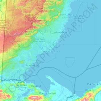
Name: Toledo District topographic map, elevation, terrain.
Location: Toledo District, Belize (15.88573 -89.22759 16.69887 -87.84221)
Average elevation: 472 ft
Minimum elevation: -3 ft
Maximum elevation: 4,364 ft
Make a donation
Gear up for your next adventure:
As an Amazon Associate, this site earns from qualifying purchases at no extra cost to you.
Other topographic maps
Click on a map to view its topography, its elevation and its terrain.
San Fransisco Heights
Belize > Cayo > San Ignacio & Santa Elena > San Ignacio
Average elevation: 423 ft
Make a donation
Gear up for your next adventure:
As an Amazon Associate, this site earns from qualifying purchases at no extra cost to you.
Make a donation
Gear up for your next adventure:
As an Amazon Associate, this site earns from qualifying purchases at no extra cost to you.
Make a donation
Gear up for your next adventure:
As an Amazon Associate, this site earns from qualifying purchases at no extra cost to you.
Make a donation
Gear up for your next adventure:
As an Amazon Associate, this site earns from qualifying purchases at no extra cost to you.
Make a donation
Gear up for your next adventure:
As an Amazon Associate, this site earns from qualifying purchases at no extra cost to you.
Make a donation
Gear up for your next adventure:
As an Amazon Associate, this site earns from qualifying purchases at no extra cost to you.
Make a donation
Gear up for your next adventure:
As an Amazon Associate, this site earns from qualifying purchases at no extra cost to you.