Geolocate

Center Point topographic map

Click on the map to display elevation.

About this map

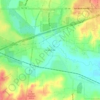
Name: Center Point topographic map, elevation, terrain.

Location: Center Point, Parker County, Texas, 76087, United States (32.72041 -97.74975 32.76041 -97.70975)

Average elevation: 961 ft

Minimum elevation: 869 ft

Maximum elevation: 1,089 ft

Parker County trails, hiking, mountain biking, running and outdoor activities

Other topographic maps

Click on a map to view its topography, its elevation and its terrain.

Cool

United States > Texas > Parker County

Average elevation: 932 ft

Sanctuary

United States > Texas > Parker County

Average elevation: 781 ft

Weatherford

United States > Texas > Parker County

Average elevation: 1,089 ft

Hudson Oaks

United States > Texas > Parker County

Average elevation: 978 ft

Weatherford

United States > Texas > Parker County

Average elevation: 1,070 ft

Gear up for your next adventure:

🪑Portable Camp Table - Compact table for campsite meals
🪓Survival Multi‑Tool - Versatile tool for camp and trail tasks
🥄Camping Utensil Set - Lightweight utensils for outdoor meals
🔭Telescopic Hiking Pole - Adjustable pole for hiking stability
🗃️Trail First Aid Kit - Essential kit for outdoor injuries and emergencies

As an Amazon Associate, this site earns from qualifying purchases at no extra cost to you.