
Make a donation
Gear up for your next adventure:
As an Amazon Associate, this site earns from qualifying purchases at no extra cost to you.
Barkhamsted topographic map
Click on the map to display elevation.
Make a donation
Gear up for your next adventure:
As an Amazon Associate, this site earns from qualifying purchases at no extra cost to you.
About this map
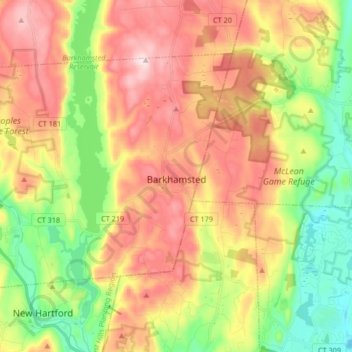
Name: Barkhamsted topographic map, elevation, terrain.
Location: Barkhamsted, Northwest Hills Planning Region, United States (41.88728 -73.05365 41.97341 -72.88770)
Average elevation: 781 ft
Minimum elevation: 226 ft
Maximum elevation: 1,385 ft
Northwest Hills Planning Region trails, hiking, mountain biking, running and outdoor activities
Make a donation
Gear up for your next adventure:
As an Amazon Associate, this site earns from qualifying purchases at no extra cost to you.
Other topographic maps
Click on a map to view its topography, its elevation and its terrain.
Yellow Mountain
United States > Northwest Hills Planning Region > New Hartford
Average elevation: 732 ft
Town of Barkhamsted property
United States > Northwest Hills Planning Region > Barkhamsted
Average elevation: 1,033 ft
East Litchfield
United States > Northwest Hills Planning Region > Litchfield
Average elevation: 784 ft
Make a donation
Gear up for your next adventure:
As an Amazon Associate, this site earns from qualifying purchases at no extra cost to you.