
West Cornwall topographic map
Click on the map to display elevation.
About this map
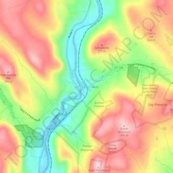
Name: West Cornwall topographic map, elevation, terrain.
Average elevation: 945 ft
Minimum elevation: 486 ft
Maximum elevation: 1,352 ft
Northwest Hills Planning Region trails, hiking, mountain biking, running and outdoor activities
Other topographic maps
Click on a map to view its topography, its elevation and its terrain.
Litchfield County
United States > Connecticut > Northwest Hills Planning Region
Average elevation: 823 ft
Highland Lake
United States > Connecticut > Northwest Hills Planning Region > Winchester
Average elevation: 1,024 ft
Norfolk
United States > Connecticut > Northwest Hills Planning Region
According to the United States Census Bureau, the town has a total area of 46.4 square miles (120.2 km2), of which 45.3 square miles (117.4 km2) are land and 1.1 square miles (2.9 km2), or 2.38%, are water. The town is located in the Litchfield Hills portion of the Appalachian mountain range. Norfolk's…
Average elevation: 1,325 ft
New Preston
United States > Connecticut > Northwest Hills Planning Region > New Preston
Average elevation: 820 ft
Litchfield County
United States > Connecticut > Northwest Hills Planning Region
Average elevation: 827 ft
Litchfield County
United States > Connecticut > Northwest Hills Planning Region
Average elevation: 827 ft
Bantam
United States > Connecticut > Northwest Hills Planning Region > Litchfield
Average elevation: 902 ft
Litchfield (borough)
United States > Connecticut > Northwest Hills Planning Region > Litchfield
Average elevation: 1,007 ft