
Kingston topographic map
Interactive map
Click on the map to display elevation.
About this map
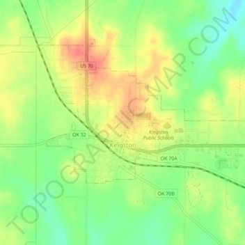
Name: Kingston topographic map, elevation, terrain.
Location: Kingston, Marshall County, Oklahoma, United States (33.98954 -96.73469 34.01380 -96.69164)
Average elevation: 784 ft
Minimum elevation: 682 ft
Maximum elevation: 892 ft
Other topographic maps
Click on a map to view its topography, its elevation and its terrain.
Lake Texoma
United States > Oklahoma > Marshall County
Lake Texoma, Marshall County, Oklahoma, United States
Average elevation: 699 ft
Antioch
United States > Oklahoma > Marshall County
Antioch, Marshall County, Oklahoma, United States
Average elevation: 883 ft
Madill
United States > Oklahoma > Marshall County
Madill, Marshall County, Oklahoma, 73446, United States
Average elevation: 814 ft
Cumberland
United States > Oklahoma > Marshall County > Cumberland
Cumberland, Marshall County, Oklahoma, United States
Average elevation: 696 ft