Geolocate

Taizhou topographic map

Click on the map to display elevation.

About this map

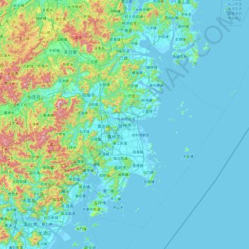
Name: Taizhou topographic map, elevation, terrain.

Location: Taizhou, Zhejiang, China (27.97163 120.28544 29.34700 122.17828)

Average elevation: 463 ft

Minimum elevation: -7 ft

Maximum elevation: 4,324 ft

Other topographic maps

Click on a map to view its topography, its elevation and its terrain.

Chian

China > Zhejiang > Jinhua

Average elevation: 427 ft

Aojiang

China > Zhejiang > Wenzhou > Aojiang

Average elevation: 102 ft

Shanxi

China > Zhejiang > Wenzhou > Shanxi

Average elevation: 951 ft

Gear up for your next adventure:

🥇GPS Hiking Watch - Multi‑sport GPS watch with navigation and trail tracking
😴Insulated Sleeping Pads - Compact and warm pads for high-elevation camping
👟Men's Trail Runners - Lightweight footwear for fast-paced exploration and light hiking
👖Convertible Hiking Pants - Versatile zip-off pants for changing altitudes and temperatures
📡GPS Antenna Upgrade - Enhance GPS reception in remote terrain

As an Amazon Associate, this site earns from qualifying purchases at no extra cost to you.