Geolocate

Fairview topographic map

Click on the map to display elevation.

About this map

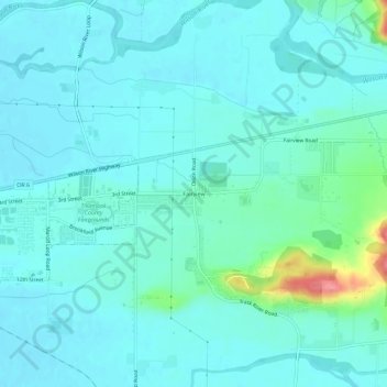
Name: Fairview topographic map, elevation, terrain.

Location: Fairview, Tillamook County, Oregon, United States (45.43753 -123.81257 45.47753 -123.77257)

Average elevation: 52 ft

Minimum elevation: 0 ft

Maximum elevation: 335 ft

Tillamook County trails, hiking, mountain biking, running and outdoor activities

Other topographic maps

Click on a map to view its topography, its elevation and its terrain.

Neahkahnie Beach

United States > Oregon > Tillamook County

Average elevation: 331 ft

Beaver

United States > Oregon > Tillamook County > Beaver

Average elevation: 253 ft

Nehalem Bay

United States > Oregon > Tillamook County

Average elevation: 108 ft

Seal Rock

United States > Oregon > Tillamook County > Oceanside

Average elevation: 36 ft

Netarts

United States > Oregon > Tillamook County > Netarts

Average elevation: 115 ft

Cloverdale

United States > Oregon > Tillamook County > Cloverdale

Average elevation: 305 ft

Gear up for your next adventure:

🪶LED Camping Lantern - Bright lantern for camp lighting
🔥Plasma Lighters - Windproof lighters that work in any weather condition
🦟Ultrasonic Repellers - Create a bug-free zone at your camp or rest stop
📦Gear Storage Bags - Organize and protect outdoor equipment
🧢Outdoor Hiking Hat - Sun protection hat for outdoor explorers

As an Amazon Associate, this site earns from qualifying purchases at no extra cost to you.