Geolocate

贺连塘 topographic map

Interactive map

Click on the map to display elevation.

About this map

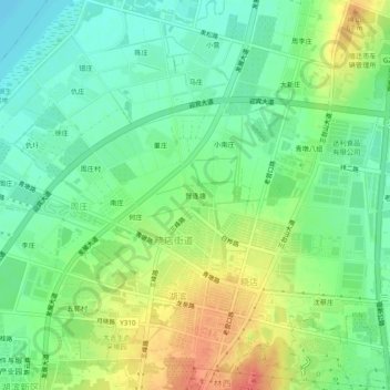
Name: 贺连塘 topographic map, elevation, terrain.

Location: 贺连塘, 晓店街道, 宿豫区, 宿迁市, 江苏省, 223809, 中国 (34.05202 118.28500 34.09202 118.32500)

Average elevation: 125 ft

Minimum elevation: 56 ft

Maximum elevation: 226 ft

Other topographic maps

Click on a map to view its topography, its elevation and its terrain.

周庄

中国 > 江苏省 > 宿豫区 > 皂河镇

周庄, 皂河镇, 宿豫区, 宿迁市, 江苏省, 中国

Average elevation: 72 ft

山下吴

中国 > 江苏省 > 宿豫区

山下吴, 晓店街道, 宿豫区, 宿迁市, 江苏省, 中国

Average elevation: 98 ft

皂河镇

中国 > 江苏省 > 宿豫区 > 皂河镇

皂河镇, 宿豫区, 宿迁市, 江苏省, 中国

Average elevation: 75 ft

傅湖

中国 > 江苏省 > 宿豫区 > 晓店街道 > 傅湖

傅湖, 晓店街道, 宿豫区, 宿迁市, 江苏省, 中国

Average elevation: 69 ft

下相街道

中国 > 江苏省 > 宿豫区 > 下相街道

下相街道, 宿豫区, 宿迁市, 江苏省, 223804, 中国

Average elevation: 66 ft

新沂河

中国 > 江苏省 > 宿豫区

新沂河, 宿豫区, Sùyù Qū, 宿迁市, 江苏省, 中国

Average elevation: 82 ft