Geolocate

Badoura topographic map

Click on the map to display elevation.

About this map

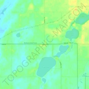
Name: Badoura topographic map, elevation, terrain.

Location: Badoura, Hubbard County, Minnesota, United States (46.84218 -94.78612 46.88218 -94.74612)

Average elevation: 1,407 ft

Minimum elevation: 1,375 ft

Maximum elevation: 1,450 ft

Hubbard County trails, hiking, mountain biking, running and outdoor activities

Other topographic maps

Click on a map to view its topography, its elevation and its terrain.

Nevis

United States > Minnesota > Hubbard County

Average elevation: 1,453 ft

Laporte

United States > Minnesota > Hubbard County

Average elevation: 1,345 ft

Many Arm Lake

United States > Minnesota > Hubbard County

Average elevation: 1,480 ft

Gear up for your next adventure:

🪶Multi‑Purpose Knife - Useful blade for camp and trail
👟Men's Trail Runners - Lightweight footwear for fast-paced exploration and light hiking
🥩Freeze-Dried Meals - Nutritious and lightweight food for remote expeditions
🪶Thermal Camp Blanket - Extra warmth for cold nights
📷Action Cameras - Rugged cameras to document your journeys across rugged terrain

As an Amazon Associate, this site earns from qualifying purchases at no extra cost to you.