Geolocate

Nevis topographic map

Click on the map to display elevation.

About this map

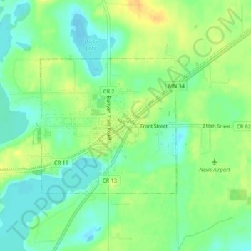
Name: Nevis topographic map, elevation, terrain.

Location: Nevis, Hubbard County, Minnesota, United States (46.95740 -94.85418 46.97193 -94.83155)

Average elevation: 1,453 ft

Minimum elevation: 1,411 ft

Maximum elevation: 1,506 ft

Hubbard County trails, hiking, mountain biking, running and outdoor activities

Other topographic maps

Click on a map to view its topography, its elevation and its terrain.

Badoura

United States > Minnesota > Hubbard County

Average elevation: 1,407 ft

Rosby

United States > Minnesota > Hubbard County

Average elevation: 1,391 ft

Many Arm Lake

United States > Minnesota > Hubbard County

Average elevation: 1,480 ft

Gear up for your next adventure:

🧭Pro Hiking Compasses - High-accuracy liquid-filled compasses for topographic orientation
🛶Inflatable Kayak - Portable kayak for rivers, lakes, and expeditions
🧣Hiking Neck Gaiter - Multi‑use neck protection for outdoor weather
🦶Carbon Trekking Poles - Reduce knee impact on steep descents with ultra-light poles
🔥Fast-Boil Camping Stoves - Efficient cooking systems for quick trail meals

As an Amazon Associate, this site earns from qualifying purchases at no extra cost to you.