Geolocate

Alvelos topographic map

Click on the map to display elevation.

About this map

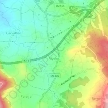
Name: Alvelos topographic map, elevation, terrain.

Location: Alvelos, Barcelos, Braga, Portugal (41.49147 -8.63130 41.51871 -8.60733)

Average elevation: 302 ft

Minimum elevation: 75 ft

Maximum elevation: 696 ft

Other topographic maps

Click on a map to view its topography, its elevation and its terrain.

Silveiros

Portugal > Braga > Barcelos

Average elevation: 446 ft

Fonte Coberta

Portugal > Braga > Barcelos

Average elevation: 384 ft

Monte do Facho

Portugal > Braga > Barcelos > Roriz

Average elevation: 397 ft

Vila Cova

Portugal > Braga > Barcelos

Average elevation: 322 ft

Feitos

Portugal > Braga > Barcelos

Average elevation: 850 ft

Milhazes

Portugal > Braga > Barcelos

Average elevation: 272 ft

Vilar do Monte

Portugal > Braga > Barcelos

Average elevation: 541 ft

Gonçalo

Portugal > Braga > Barcelos

Average elevation: 1,138 ft

Franqueira

Portugal > Braga > Barcelos

Average elevation: 479 ft

Martim de Além

Portugal > Braga > Barcelos > Martim

Average elevation: 440 ft

Durrães

Portugal > Braga > Barcelos

Average elevation: 433 ft

Gear up for your next adventure:

🔦Compact Flashlight - Reliable flashlight for emergencies
🏕️Family Camping Gear - Essentials for group camping trips
👟Trail Running Shoes - Lightweight shoes for trail runners
🦺Reflective Outdoor Gear - Safety gear for low‑light conditions
🏔️Mountain Trail Maps - High‑detail maps for popular peaks

As an Amazon Associate, this site earns from qualifying purchases at no extra cost to you.