Geolocate

8th district topographic map

Click on the map to display elevation.

About this map

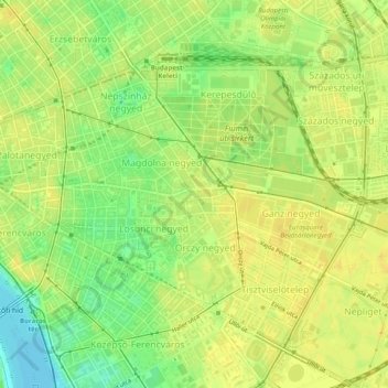
Name: 8th district topographic map, elevation, terrain.

Location: 8th district, Budapest, Central Hungary, Hungary (47.47562 19.05996 47.50199 19.10907)

Average elevation: 377 ft

Minimum elevation: 328 ft

Maximum elevation: 400 ft

Other topographic maps

Click on a map to view its topography, its elevation and its terrain.

Danube

Hungary > Budapest

Average elevation: 374 ft

Kis-Sváb-hegy

Hungary > Budapest

Average elevation: 640 ft

Gellért Hill

Hungary > Budapest

Average elevation: 413 ft

Ziggurat

Hungary > Budapest

Average elevation: 354 ft

Csúcs-hegy

Hungary > Budapest

Average elevation: 856 ft

Gellért Hill

Hungary > Budapest

Average elevation: 413 ft

Tigers

Hungary > Budapest

Average elevation: 364 ft

Danube

Hungary > Budapest

Average elevation: 410 ft

Gear up for your next adventure:

🏫Relief Map Kits - Hands-on tools for teaching landforms and elevation
🧭Map Reading Tools - Tools and kits for map navigation
🧭GPS Watch Accessories - Bands and chargers for GPS watches
Backpacking Tent - Lightweight and durable tent for multi‑day hikes
📷Action Camera - Capture your outdoor adventures in HD

As an Amazon Associate, this site earns from qualifying purchases at no extra cost to you.