
Make a donation
Gear up for your next adventure:
As an Amazon Associate, this site earns from qualifying purchases at no extra cost to you.
Buhl topographic map
Click on the map to display elevation.
Make a donation
Gear up for your next adventure:
As an Amazon Associate, this site earns from qualifying purchases at no extra cost to you.
Buhl
Buhl is located at 42°36′0″N 114°45′43″W / 42.60000°N 114.76194°W / 42.60000; -114.76194 (42.600102, -114.761867), at an elevation of 3,770 feet (1,149 m) above sea level.
Make a donation
Gear up for your next adventure:
As an Amazon Associate, this site earns from qualifying purchases at no extra cost to you.
About this map
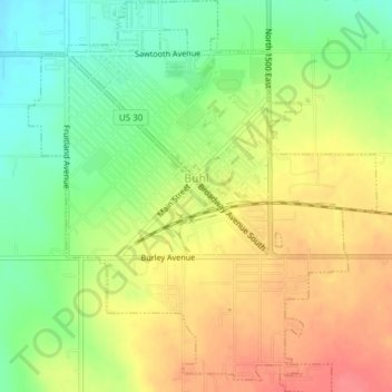
Name: Buhl topographic map, elevation, terrain.
Location: Buhl, Twin Falls County, Idaho, United States (42.58381 -114.77574 42.61167 -114.74207)
Average elevation: 3,770 ft
Minimum elevation: 3,658 ft
Maximum elevation: 3,878 ft
Twin Falls County trails, hiking, mountain biking, running and outdoor activities
Make a donation
Gear up for your next adventure:
As an Amazon Associate, this site earns from qualifying purchases at no extra cost to you.
Other topographic maps
Click on a map to view its topography, its elevation and its terrain.