
Haardt topographic map
Interactive map
Click on the map to display elevation.
About this map
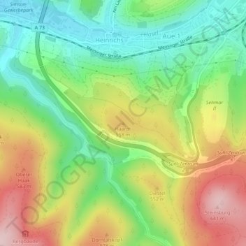
Name: Haardt topographic map, elevation, terrain.
Location: Haardt, Suhl, Thüringen, 98529, Deutschland (50.59095 10.65814 50.59105 10.65824)
Average elevation: 1,631 ft
Minimum elevation: 1,266 ft
Maximum elevation: 2,126 ft
Other topographic maps
Click on a map to view its topography, its elevation and its terrain.
Schneekopf
Deutschland > Thüringen > Suhl
Schneekopf, Suhl, Thüringen, 98528, Deutschland
Average elevation: 2,805 ft
Wichtshausen
Deutschland > Thüringen > Suhl
Wichtshausen, Suhl, Thüringen, 98530, Deutschland
Average elevation: 1,463 ft
Albrechts
Deutschland > Thüringen > Suhl
Albrechts, Suhl, Thüringen, 98529, Deutschland
Average elevation: 1,611 ft
Vesser
Deutschland > Thüringen > Suhl
Vesser, Suhl, Thüringen, 98528, Deutschland
Average elevation: 2,356 ft
Großer Beerberg
Deutschland > Thüringen > Suhl
Großer Beerberg, Suhl, Thüringen, 98528, Deutschland
Average elevation: 2,799 ft
Domberg
Deutschland > Thüringen > Suhl
Domberg, Suhl, Thüringen, 98527, Deutschland
Average elevation: 1,703 ft
Lauter
Deutschland > Thüringen > Suhl > Lauter
Lauter, Suhl, Thüringen, 98527, Deutschland
Average elevation: 1,867 ft
Schmücke
Deutschland > Thüringen > Suhl
Schmücke, Gehlberg, Suhl, Thüringen, 98528, Deutschland
Average elevation: 2,680 ft
Heidersbach
Deutschland > Thüringen > Suhl > Heidersbach
Heidersbach, Suhl, Thüringen, 98528, Deutschland
Average elevation: 2,116 ft
Heinrichs
Deutschland > Thüringen > Suhl
Heinrichs, Suhl, Thüringen, 98529, Deutschland
Average elevation: 1,594 ft