
Province of Sechura topographic map
Interactive map
Click on the map to display elevation.
About this map
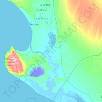
Name: Province of Sechura topographic map, elevation, terrain.
Location: Province of Sechura, Piura, Peru (-6.37209 -81.14956 -5.31105 -80.05298)
Average elevation: 157 ft
Minimum elevation: -85 ft
Maximum elevation: 1,503 ft
Other topographic maps
Click on a map to view its topography, its elevation and its terrain.
Nuevo Pozo Oscuro
Peru > Piura > Cristo nos Valga
Nuevo Pozo Oscuro, Cristo nos Valga, Province of Sechura, Piura, Peru
Average elevation: 72 ft
Morropón District
Morropón District, Province of Morropón, Piura, Peru
Average elevation: 1,463 ft
Pico de Loro
Pico de Loro, Jililí, Province of Ayabaca, Piura, Peru
Average elevation: 3,894 ft
Ayabaca
Peru > Piura > Distrito de Ayabaca
Ayabaca, Distrito de Ayabaca, Province of Ayabaca, Piura, Peru
Average elevation: 7,769 ft
Parque Miguel Cortés
Parque Miguel Cortés, Urbanización 4 de Enero, Piura, Province of Piura, Piura, Peru
Average elevation: 105 ft