
Make a donation
Gear up for your next adventure:
As an Amazon Associate, this site earns from qualifying purchases at no extra cost to you.
Pinehurst topographic map
Click on the map to display elevation.
Make a donation
Gear up for your next adventure:
As an Amazon Associate, this site earns from qualifying purchases at no extra cost to you.
Pinehurst
Pinehurst is located at 47°32′14″N 116°14′14″W / 47.53722°N 116.23722°W / 47.53722; -116.23722 (47.537193, -116.237085). at an elevation of 2,224 feet (678 m) above sea level.
Make a donation
Gear up for your next adventure:
As an Amazon Associate, this site earns from qualifying purchases at no extra cost to you.
About this map
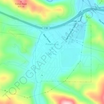
Name: Pinehurst topographic map, elevation, terrain.
Location: Pinehurst, Shoshone County, Idaho, 83850, United States (47.52881 -116.24387 47.54473 -116.22235)
Average elevation: 2,392 ft
Minimum elevation: 2,169 ft
Maximum elevation: 2,976 ft
Shoshone County trails, hiking, mountain biking, running and outdoor activities
Make a donation
Gear up for your next adventure:
As an Amazon Associate, this site earns from qualifying purchases at no extra cost to you.
Other topographic maps
Click on a map to view its topography, its elevation and its terrain.
Make a donation
Gear up for your next adventure:
As an Amazon Associate, this site earns from qualifying purchases at no extra cost to you.