Geolocate

South Browning topographic map

Click on the map to display elevation.

About this map

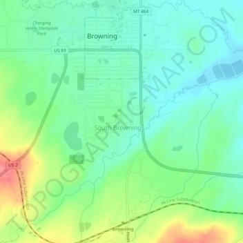
Name: South Browning topographic map, elevation, terrain.

Location: South Browning, Glacier County, Montana, United States (48.53137 -113.03422 48.56225 -112.98758)

Average elevation: 4,413 ft

Minimum elevation: 4,331 ft

Maximum elevation: 4,580 ft

Glacier County trails, hiking, mountain biking, running and outdoor activities

Other topographic maps

Click on a map to view its topography, its elevation and its terrain.

Many Glacier

United States > Montana > Glacier County

Average elevation: 5,440 ft

North Browning

United States > Montana > Glacier County

Average elevation: 4,383 ft

Shepard Glacier

United States > Montana > Glacier County

Average elevation: 7,077 ft

Calf Robe Mountain

United States > Montana > Glacier County

Average elevation: 6,627 ft

Chief Mountain

United States > Montana > Glacier County

Average elevation: 7,205 ft

Pray Lake

United States > Montana > Glacier County

Average elevation: 5,633 ft

Cracker Lake

United States > Montana > Glacier County

Average elevation: 7,297 ft

Durham

United States > Montana > Glacier County > Durham

Average elevation: 4,816 ft

Bison

United States > Montana > Glacier County > Bison

Average elevation: 5,174 ft

Bullhead Lake

United States > Montana > Glacier County

Average elevation: 6,063 ft

Gear up for your next adventure:

👟Men's Trail Runners - Lightweight footwear for fast-paced exploration and light hiking
🧭Pro Hiking Compasses - High-accuracy liquid-filled compasses for topographic orientation
🧢Sun Protection Hats - Wide-brimmed and UPF-rated hats for high-altitude sun safety
🏫Relief Map Kits - Hands-on tools for teaching landforms and elevation
🛰️Satellite Messengers - Emergency SOS and two-way messaging for off-grid adventures

As an Amazon Associate, this site earns from qualifying purchases at no extra cost to you.