
Aurora topographic map
Click on the map to display elevation.
About this map
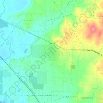
Name: Aurora topographic map, elevation, terrain.
Location: Aurora, Wise County, Texas, United States (33.03673 -97.53367 33.08291 -97.48670)
Average elevation: 748 ft
Minimum elevation: 656 ft
Maximum elevation: 932 ft
Wise County trails, hiking, mountain biking, running and outdoor activities
Other topographic maps
Click on a map to view its topography, its elevation and its terrain.
Sid Richardson Scout Ranch
United States > Texas > Wise County > Lake Bridgeport
Average elevation: 906 ft