
Make a donation
Gear up for your next adventure:
As an Amazon Associate, this site earns from qualifying purchases at no extra cost to you.
Runaway Bay topographic map
Click on the map to display elevation.
Make a donation
Gear up for your next adventure:
As an Amazon Associate, this site earns from qualifying purchases at no extra cost to you.
About this map
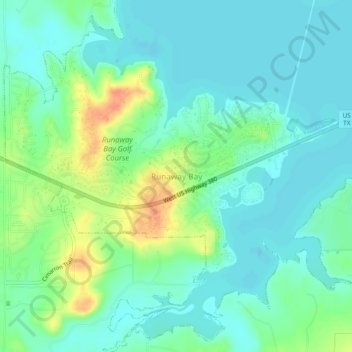
Name: Runaway Bay topographic map, elevation, terrain.
Location: Runaway Bay, Wise County, Texas, United States (33.14789 -97.89837 33.18789 -97.85837)
Average elevation: 866 ft
Minimum elevation: 820 ft
Maximum elevation: 978 ft
Wise County trails, hiking, mountain biking, running and outdoor activities
Make a donation
Gear up for your next adventure:
As an Amazon Associate, this site earns from qualifying purchases at no extra cost to you.
Other topographic maps
Click on a map to view its topography, its elevation and its terrain.
Make a donation
Gear up for your next adventure:
As an Amazon Associate, this site earns from qualifying purchases at no extra cost to you.
Sid Richardson Scout Ranch
United States > Texas > Wise County > Lake Bridgeport
Average elevation: 906 ft